An Inventory of the Historical Monuments in the County of Northamptonshire, Volume 4, Archaeological Sites in South-West Northamptonshire. Originally published by Her Majesty's Stationery Office, London, 1982.
This free content was digitised by double rekeying. All rights reserved.
'Newbottle', in An Inventory of the Historical Monuments in the County of Northamptonshire, Volume 4, Archaeological Sites in South-West Northamptonshire(London, 1982), British History Online https://prod.british-history.ac.uk/rchme/northants/vol4/pp103-108 [accessed 1 February 2025].
'Newbottle', in An Inventory of the Historical Monuments in the County of Northamptonshire, Volume 4, Archaeological Sites in South-West Northamptonshire(London, 1982), British History Online, accessed February 1, 2025, https://prod.british-history.ac.uk/rchme/northants/vol4/pp103-108.
"Newbottle". An Inventory of the Historical Monuments in the County of Northamptonshire, Volume 4, Archaeological Sites in South-West Northamptonshire. (London, 1982), British History Online. Web. 1 February 2025. https://prod.british-history.ac.uk/rchme/northants/vol4/pp103-108.
In this section
43 NEWBOTTLE
(OS 1:10000 a SP 53 NW, b SP 53 SW, c SP 53 NE)
The long parish, of irregular shape, now covers 925 hectares but has undergone several changes of its boundaries (Fig. 82). It incorporates the village and lands of Charlton and the deserted hamlet and lands of Purston as well as the territory of the village of Newbottle itself which is also now deserted. The parish slopes generally W., drained by S.W.-flowing streams. The high ground in the S. and E. between 120 m. and 150 m. above OD is an extensive outcrop of Great Oolite Limestone and Northampton Sand, which gives way to Upper Lias Clay in the W. and on the valley sides. The possible implications of the complex relationship between this parish and its neighbours, King's Sutton and Farthinghoe, have already been published (F. M. Brown and C. C. Taylor, 'Settlement and Land Use in Northants.' in BAR, International Series (Supplementary), 68 (1978), 77–89).
The small Iron Age hill fort known as Rainsborough Camp (1) on the S. boundary of the parish, is perhaps the most important monument, but the deserted village of Newbottle (3) and the garden remains and settlement remains at Purston (5) and (4) are also noteworthy.
Prehistoric and Roman
A Mesolithic core is recorded from the S. of the parish (Banbury Museum; CBA Research Report, 20 (1977), 217) though the published grid (SP 520430) locates it in Aynho parish.
Two Roman gold coins were found in the parish in the early part of the 18th century, one of Titus from Charlton and one of Vespasian 'a little distance from Rainsborough Camp' (J. Bridges, Hist. of Northants., I (1791), 190; VCH Northants., I (1902), 216). Roman pottery, one complete pewter plate and a fragment of a second, are recorded as having been found in Hill Spinney. No wood of that name is known and it seems most likely that the finds were made during extensive quarrying in Newbottle Spinney (around SP 517365). (NM; VCH Northants., I (1902), 218; CBA Group 9, Newsletter, 6 (1976), 218)
Several undated skeletons are recorded from Newbottle Spinney, and these also may have come from the stone quarries (A. Beesley, Hist. of Banbury (1841), 35).

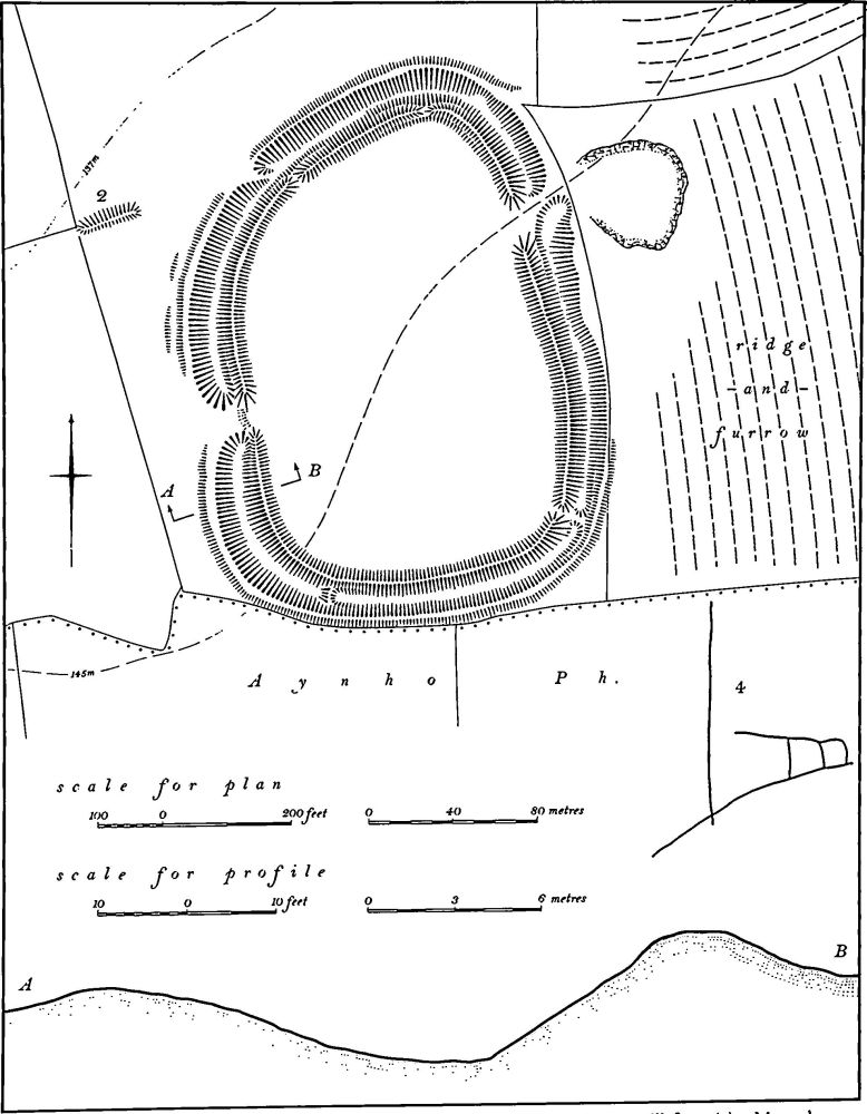
Fig. 87 Aynho (4) Enclosures and ditches, Newbottle (1) Hill fort, (2) Mound
b(1) Hill Fort (SP 526348; Fig. 87), known as Rainsborough Camp, lies on the northern edge of a level plateau of limestone in the extreme S. of the parish at 145 m. above OD. There are extensive views to the N. and N.W. across the Cherwell valley and over much of King's Sutton and Newbottle parishes, but to the S. and S.E. the land is flat.
The fort comprises a roughly oval area of some 2.6 hectares, bounded by a double bank and ditch. The inner bank is up to 3 m. high above the interior with an outer ditch 4 m. deep below the summit. Beyond is an outer bank, reduced by cultivation on the W. and N. to no more than 0.5 m. high and completely removed on the E. On the S. it still survives up to 1 m. high. The outer ditch has disappeared completely except for slight traces along the W. side. The main inner rampart has a dry-stone wall, in places still 0.75 m. high, set half way up the outer slope. This is visible over large lengths of the rampart and was presumably once a continuous feature.
There are several gaps through the defences. The minor ones on the N. and N.W. were made in the 17th century for local traffic, and magnetometer surveys carried out during the excavations showed that only the western entrance was original. The eastern one may be Roman. The interior is flat and featureless, having been under cultivation in the past. The site was extensively excavated between 1961 and 1965 and the prehistoric phases were published in full (PPS, 33 (1967), 207–306). Only a brief summary of the results is therefore given here. Eight phases of occupation were established:
1. Early Iron Age I (possibly 5th/6th centuries BC). Pre-fort occupation represented by post-holes and occupation debris.
2. Early Iron Age IIa (possibly 5th century BC). Bivallate fort constructed. Simple entrance on the W. had stone guardrooms within the inturns. One hut and two roofed working hollows in the interior also probably belonged to this phase.
3. Early Iron Age IIb (possibly early 4th century BC). A period of occupation with replacements or repairs made to the entrance, and the inner ditch cleaned out.
4. Early Iron Age IIIa (possibly early 4th century BC). Fort burnt and guardrooms destroyed.
5. Early Iron Age IIIb (4th to 2nd century BC). Fort perhaps abandoned.
6. Early Iron Age IV (late 2nd century BC). Site refortified and entrance rebuilt. One hut and a pit indicated that the interior was reoccupied.
7. Roman I (late 1st century AD). Occupation debris.
8. Roman II (3rd to 4th century AD). Stone building erected near entrance which was remodelled.
In the 18th century the inner bank was heightened and the dry-stone walling added to it. The inner ditch was deepened. This was carried out about 1772 as part of a landscaping scheme. Among the other recorded finds from the site in addition to those made during the excavation are 'broken pots, glass and ashes' found c. 1700 when the interior was ploughed and levelled (J. Bridges. Hist. of Northants., I (1791), 190), 'numerous Roman coins, now all lost' (G. Baker, Hist. of Northants., I (1822–30), 666), 'a piece of an antique Helmet' (J. Morton, Nat. Hist. of Northants. (1712), 86–7), 'a large quantity of gold coins' (A. Beesley, Hist. of Banbury (1841) 36), an iron arrowhead (PSA, I (1861), 324; JBAA, 17 (1861), 70), and pots and glass found during the cutting of a gap in the rampart in the late 17th century (Bodleian Ms. Wood D. 18 (8563), Fol. iii and Wood F. 32 (8494), Fol. 122).
The possibility that the fort was the centre of a large Iron Age estate which remained intact into the medieval period has been suggested (F. M. Brown and C. C. Taylor, op. cit.). (RAF VAP CPE/UK/1926, 4210–1; CPE/UK/1929, 3170–2; 106G/UK/1488, 4269–70; CUAP, AAV21, AJJ16, AML59, ANT73)
b(2) Mound (SP 524349; Fig. 87), lies on the edge of a slope 60 m. N.W. of the N.W. corner of Rainsborough Camp (1), on limestone at 146 m. above OD. The mound is 30 m. long and 4 m. wide and only 0.25 m. high above the adjacent ground to the S., but almost 1 m. high above the ground to the N. The N. side has dry-stone walling set into it. It is traditionally known as 'The Barrow'. In its present form it appears to be a relatively modern feature and indeed the dry-stone walling must date from the late 18th century when the hill fort was given a similar wall. However it was perhaps only altered then for Morton (Nat. Hist. of Northants. (1712), 86) refers to a small 'piece of ground entrenched' to the S.E. of Rainsborough. As Morton appears to have reversed the compass points when describing the fort, this is probably the feature to which he refers.
For enclosures and ditches immediately S. of Rainsborough Camp (1), see Aynho (4).
For possible Roman Road 56a, see Appendix.
Medieval and Later
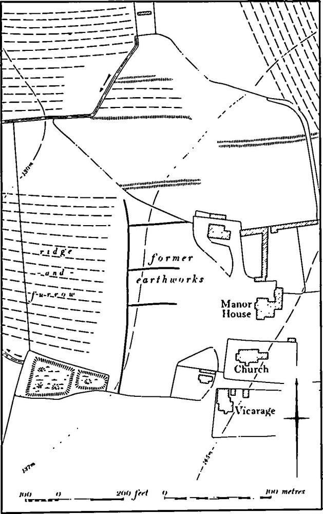
a(3) Deserted Village of Newbottle (SP 524368; Fig. 82 and 88), lies around the now isolated church, vicarage and manor house, on land sloping W. on Northampton Sand and Oolite Limestone at 140 m. above OD. The village is first recorded in 1086 when Domesday Book lists it as a single manor with a total recorded population of 32 (VCH Northants., I (1902), 331). However this figure certainly referred to more than the village itself for the manor is described as cum appendiciis suis, and the entry almost certainly includes Little Purston, now in King's Sutton parish, and perhaps part of Charlton. In 1301, 23 people at Newbottle paid the Lay Subsidy (PRO, E179/155/31) but again this figure may be inflated by the inclusion of other places. The village was recognised as an independent vill in the Nomina Villarum of 1316. In 1488 six houses there were destroyed and three hundred acres of land enclosed by Henry Lord Grey. In 1524 only three people paid the Lay Subsidy (PRO, E179/155/146) and by 1547 a thousand sheep were being grazed on the land of the village (K. J. Allison, et al., The Deserted Villages of Northants. (1966), 43). By the mid 19th century the village was exactly as it is today (NRO, Tithe Map, 1844).
Very little remains of the village earthworks. There is some uneven ground S. of the church and vicarage, but parts of this are shallow quarries and the rest is the site of temporary buildings constructed during the Second World War. To the N.W. of the manor house are the ploughedover remains of some small rectangular closes. one with ridge-and-furrow within it, bounded by low scarps and shallow ditches. Before destruction these earthworks ex tended further S. and medieval pottery mainly of 14th-century date has been found in the area. Further S.W. two rectangular ponds lie within a small copse. These certainly existed in 1844. A little to the N. of the manor house (SP 525373) 'sheet bronze', a clay pipe bowl, lead and medieval and later pottery have been found (Oxoniensia, 36 (1972), 122). (RAF VAP CPE/UK/1926, 2210–11; air photographs in NMR)
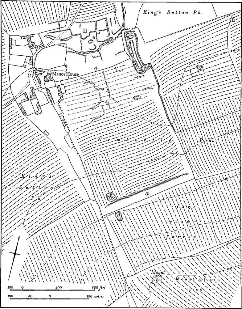
a(4) Deserted Hamlet of Purston (SP 518395; Figs. 82 and 89), lay in the N. of the parish, on Marlstone Rock at 113 m. above OD. The hamlet was the southernmost of two settlements, both with the same name, side by side and separated only by the parish boundary with King's Sutton but each having its own associated land unit. The documented history is given under the northern settlement of Purston (King's Sutton (11)).

Fig. 88 Newbottle (3) Deserted village
Nothing survives of the settlement on the ground, the area having been ploughed and returned to grassland. On air photographs taken before this destruction (RAF VAP CPE/ UK/1926, 2510–11) some slight traces of embanked closes partly over-ploughed by later ridge-and-furrow are visible immediately S. of the parish boundary. It is possible that a street lay along the boundary.
a(5) Garden Remains (SP 519394; Fig. 89), lay to the S.E. of the manor house of Great Purston, on Marlstone Rock between 114 m. and 152 m. above OD. Little is known of the history of the garden and almost all the earthworks have been destroyed. The site is of interest in that it appears to have covered an unusually large area.
The gardens, though apparently never finished, were clearly intended to provide a backcloth to the existing manor house extending from the main S. front of the house across generally level ground and then across the steeply rising ground further S. The house is partly of late 16th or early 17th-century date but the S. facade is of the late 17th century (N. Pevsner, Northamptonshire (1973), 379) and it is possible that the gardens are of the later period. The intended design appears to be more akin to mid or late 17th-century precepts.
There seem to have been three main parts to the garden. In the N., fronting the house but also extending E., was a large rectangular area covering some 8.5 hectares. At its S. end was a broad terrace ('a' on plan) which, though now ploughed down, is still 18 m. wide and 2 m. high. This terrace must have provided a walkway and a view over a formal garden between it and the house. However it is clear that the formal garden was never completed, for air photographs taken before modern ploughing (RAF VAP CPE/UK/1926, 5210–11) show that most of the area still had undamaged ridge-and-furrow on it. At the N. end of the area, close to the house, the air photographs show a rectangular layout of scarps and other disturbances which are overlaid by later ridge-and-furrow. These appear to be the remains of the deserted hamlet of Purston (4). In the N.E. corner of this section of the garden, within a small copse, is a pond with a rectangular 'moated' island in its S. part. This may also have been part of the garden design. The central section of the garden, beyond the terrace, lies on steeply sloping ground. In a typical late 16th or early 17th-century garden of this size there would have been a 'wilderness' or woodland, but the older air photographs show undisturbed ridge-and-furrow here and it seems unlikely that such a wilderness was ever laid out.
The third part of the garden lay further S., on top of the hill. On a map of Purston of 1768 (NRO) the large field here is called Mount Close and a circular feature described as 'Mount' is depicted at the N. end, overlooking the rest of the garden and the manor house. To the E., on flatter ground, is a small close called 'Bowling Green'. Both these features would be expected in a garden of the late 16th century. Again, however, the 1947 air photographs show undisturbed ridge-and-furrow in the area of the mount, though on the ground there is a low natural knoll at this point ('b' on plan). No trace remains of the bowling green, but the whole area was under cultivation in 1844 (NRO, Tithe Map of Newbottle).

Fig 89 King's Sutton (11) Deserted hamlet of Purston, Newbottle (4) Deserted hamlet of Purston, (5) Garden remains
b(6) Mound (SP 52603449), lies on Marlstone Rock, on land sloping N.E. at 130 m. above OD. The mound is now ploughed over, only 0.25 m. high and 14 m. in diam. In 1947 (RAF VAP CPE/UK/1926, 5210–11), before ploughing, it appears to have been considerably higher and was sur rounded by ridge-and-furrow. However the exact relationship with the latter is unclear.
(7) Cultivation Remains (Fig. 82). The complex pattern of settlements and land units in Newbottle makes it difficult to understand the arrangement of the medieval fields there. There were presumably at least three systems, those of Newbottle, Charlton and Purston.
The common fields of Charlton were enclosed by an Act of Parliament of 1772, but no map is known. Ridge-and-furrow of these fields exists on the ground and or can be traced on air photographs in only a few places within the land attributed to Charlton. Most of it lies S. and S.E. of the village, especially to the E. of Rainsborough Camp where it is arranged in end-on and interlocked furlongs. On the flat limestone areas N.E. of the village modern cultivation has destroyed all trace except along the valley sides where the ridges run at right angles to the contours.
The date of enclosure of the common fields of the deserted village of Newbottle is not known, except that three hundred acres were enclosed for pasture in 1488 and a thousand sheep were being kept there in 1547 (K.J. Allison et al., The Deserted Villages of Northants. (1966), 43). Only a few fragments of the ridge-and-furrow of these fields survive but air photographs show more on the broken land to the N. of the former village and in the extreme S. of the land of Newbottle. Here the apparently irregular pattern of furlongs is the result of careful construction of the ridges at right angles to the contours.
The date of the enclosure of the common fields of the deserted hamlet of Purston (4) is also unknown, though 280 acres of land either here or in the Purston of King's Sutton, or in both, were enclosed for pasture in 1495 (K. J. Allison, op. cit., 45). Although little ridge-and-furrow now exists, air photographs show the pattern of interlocked and end-on furlongs almost complete. There are two points of interest. Part of the area was apparently still ploughed in ridge-and-furrow as late as 1844, within the existing field boundaries (NRO, Tithe Map of Newbottle). Secondly, the air photographs show that on the steep N.-facing slope towards the S. of the land of Purston (SP 523394) the ridge-and-furrow had been disturbed by a comparatively modern landslip or mud-flow. (RAF VAP 106G/UK/1488, 3230–2, 4265–71; CPE/UK/1926, 2210–13, 4210–15; CPE/UK/1929, 3170–4)
