An Inventory of the Historical Monuments in the County of Northamptonshire, Volume 4, Archaeological Sites in South-West Northamptonshire. Originally published by Her Majesty's Stationery Office, London, 1982.
This free content was digitised by double rekeying. All rights reserved.
'Greatworth', in An Inventory of the Historical Monuments in the County of Northamptonshire, Volume 4, Archaeological Sites in South-West Northamptonshire(London, 1982), British History Online https://prod.british-history.ac.uk/rchme/northants/vol4/pp64-70 [accessed 8 February 2025].
'Greatworth', in An Inventory of the Historical Monuments in the County of Northamptonshire, Volume 4, Archaeological Sites in South-West Northamptonshire(London, 1982), British History Online, accessed February 8, 2025, https://prod.british-history.ac.uk/rchme/northants/vol4/pp64-70.
"Greatworth". An Inventory of the Historical Monuments in the County of Northamptonshire, Volume 4, Archaeological Sites in South-West Northamptonshire. (London, 1982), British History Online. Web. 8 February 2025. https://prod.british-history.ac.uk/rchme/northants/vol4/pp64-70.
In this section
27 GREATWORTH
(OS 1:10000 a SP 54 SE b SP 54 SW c SP 53 NE)
The large parish, of some 1570 hectares, incorporates the medieval settlements and parishes of Stuchbury and Halse, both now deserted, as well as Greatworth itself (Fig. 61). The hamlet of Westhorp, which is contiguous with Greatworth village, was formerly in Marston St. Lawrence but is now in Greatworth parish. The parish lies on a watershed between streams flowing to the Rivers Tove, Cherwell and Great Ouse. The higher ground in the E., at about 150 m. above OD, is blanketed by Boulder Clay. Bands of Oolitic Limestone and Northampton Sand as well as expanses of Upper Lias Clay slope down to the stream on the S.W. boundary, at about 115m. above OD.
The major monuments in the parish are the deserted villages of Stuchbury (10) and Halse (13) and the garden remains (9) at Greatworth.
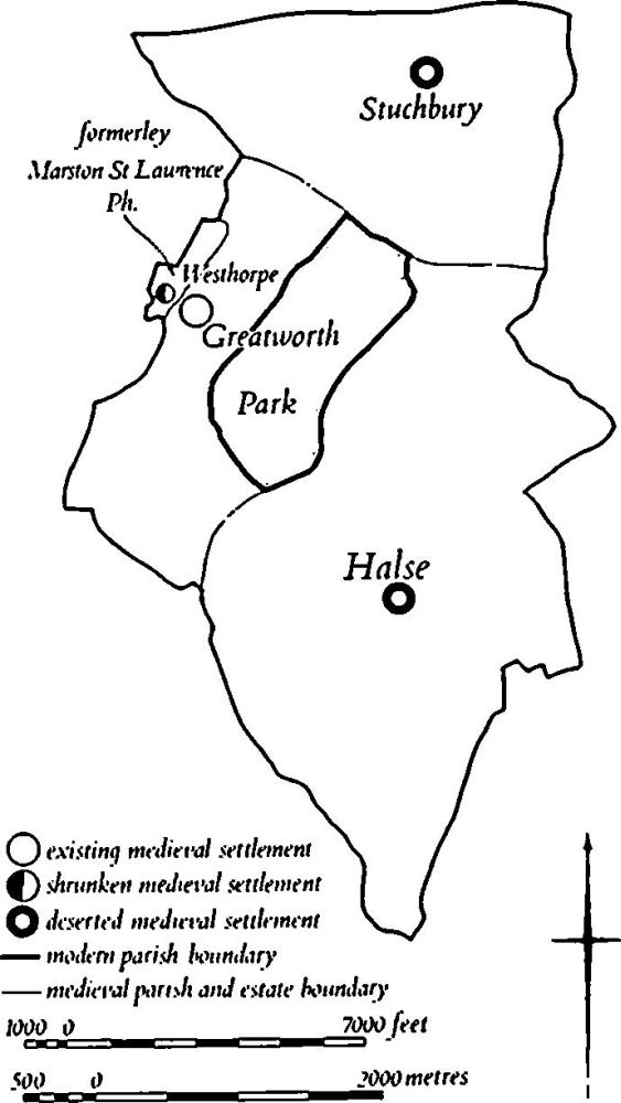
Fig. 61 Greatworth Medieval settlements and estates, (12) Deer park
Prehistoric and Roman
A fragment of a perforated disc of silty mudstone has been found in the parish (at SP 549419; NM Records) and small quantities of worked flints of late Neolithic or early Bronze Age type in three places (SP 55904213, 55604186, 55734158; inf. D. J. Barrett).
a(1) Roman Settlement (?) (SP 553425), immediately N.E. of the village of Greatworth, on limestone at 160 m. above OD. Roman sherds have been noted (OS Record Cards).
a(2) Roman Settlement (SP 560416), S.E. of the village, on Upper Lias Clay at 132 m. above OD. A large quantity of Roman pottery including samian and mortarium sherds was found in 1978 (Northants. Archaeol., 14 (1979), 105).
a(3) Roman Settlement (?) (SP 559435), S. of Stuchbury, on Boulder Clay at 168 m. above OD. A small Roman site is recorded (Northants. Archaeol., 11 (1976), 192; CBA Group 9, Newsletter, 6 (1976), 29).
b(4) Roman Settlement (?) (centred SP 550417), S. of the village, on Upper Lias Clay at about 125 m. above OD. Small scatters of Roman pottery and tile as well as worked flints and one arrowhead have been found dispersed over an area of 10 hectares (inf. D. J. Barrett).
b(5) Roman Settlement (?) (SP 550422), on the S.W. edge of the village, on limestone and Northampton Sand at 152 m. above OD. A small quantity of Roman pottery and tiles has been discovered (inf. D. J. Barrett).
b(6) Roman Settlement (?) (SP 549410), E. of Cockleyhill Farm, on Upper Lias Clay at 137 m. above OD. A small quantity of Roman pottery and some worked flints are recorded (inf. D. J. Barrett).
b(7) Roman Settlement (SP 560406), N.W. of Halse, on limestone at 152 m. above OD. Roman pottery extends over about 6 hectares and a fragment of a flint axe has been found on the S.E. side of the site (inf. D. J. Barrett).
Medieval and Later
An Anglo-Saxon gilt-bronze disc brooch was found in 1957, probably in Greatworth (J. Northants. Mus. and Art Gall., 10 (1974), 18–19; NM).
b(8) Settlement Remains (SP 549424; Fig. 62), formerly part of Westhorp, lay on the S.E. side of the hamlet, on limestone at 157 m. above OD. Westhorp, though probably always contiguous with the village of Greatworth, was formerly part of Marston St. Lawrence parish and has been transferred to Greatworth only in recent years (NRO, Enclosure Map of Marston St. Lawrence, 1760; OS 1:2500 Northants. LVII 18 and LIX 5 (1925)). The origins and relationship of the hamlet to both Marston St. Lawrence and Greatworth are obscure.
The remains have now been entirely destroyed and the site built over. However on air photographs taken in 1947 (RAF VAP CPE/UK/1926, 3214–5) a small paddock of just over 1 hectare is visible, divided into at least seven rectangular closes bounded by low banks and scarps. No definite house-sites can be recognised.
a(9) Site of Manor House and Garden (SP 552421; Fig. 63), lies on the S. side of Greatworth village, immediately S. of the present manor house, on the crest of a S.-facing slope with extensive views, on Northampton Sand at 152 m. above OD. The medieval manor house of Great worth was rebuilt in the early 18th century by Charles Howe (1661–1742). In 1752 the estate was sold to William Higginson who leased the house to George Montagu from 1753 to 1768. The house was destroyed by fire in 1793. (Northants. P. and P., 5 (1976), 311–14)
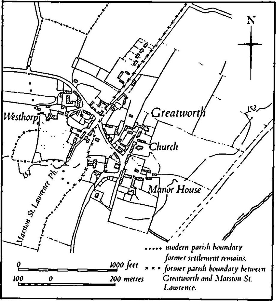
Fig. 62 Greatworth (8) Settlement remains at Westhorp
The present manor house appears to contain fragments of the 18th-century house and to judge from a painting of 1721 this earlier building stood immediately to the S.E. It was a large rectangular building of three storeys with a symmetrical S. elevation surmounted by a balustrade. The original gate piers, topped by elaborate pineapples, survive to the W., as well as parts of the stabling to the N. The site of the house itself is now covered by a modern garden, but below it on the sloping hillside are the remains of the contemporary garden covering about I hectare. This is a rectangular area, bounded on most of three sides by a stone wall with shallow pilasters at intervals. In the S.W. corner are the slight remains of a flat-topped terrace-walk only 0.5 m. high which probably extended the whole length of the S. side. Across the centre of the site runs a broad scarp 1.5 m. high but now much degraded, with a rectangular pond at its E. end. The pond still retains fragments of a revetment of dry-stone walling up to 2 m. high. Below the pond, in the S.E. of the garden, is another low scarp only 1 m. high. A track crossing the area from N.W. to S.E. has apparently destroyed further very low scarps visible on air photographs taken in 1947 (RAF VAP CPE/UK/ 1926, 3214–5). The remains suggest that the garden was of typical early 18th-century type, divided into rectangular compartments but with views over the surrounding countryside to the S.
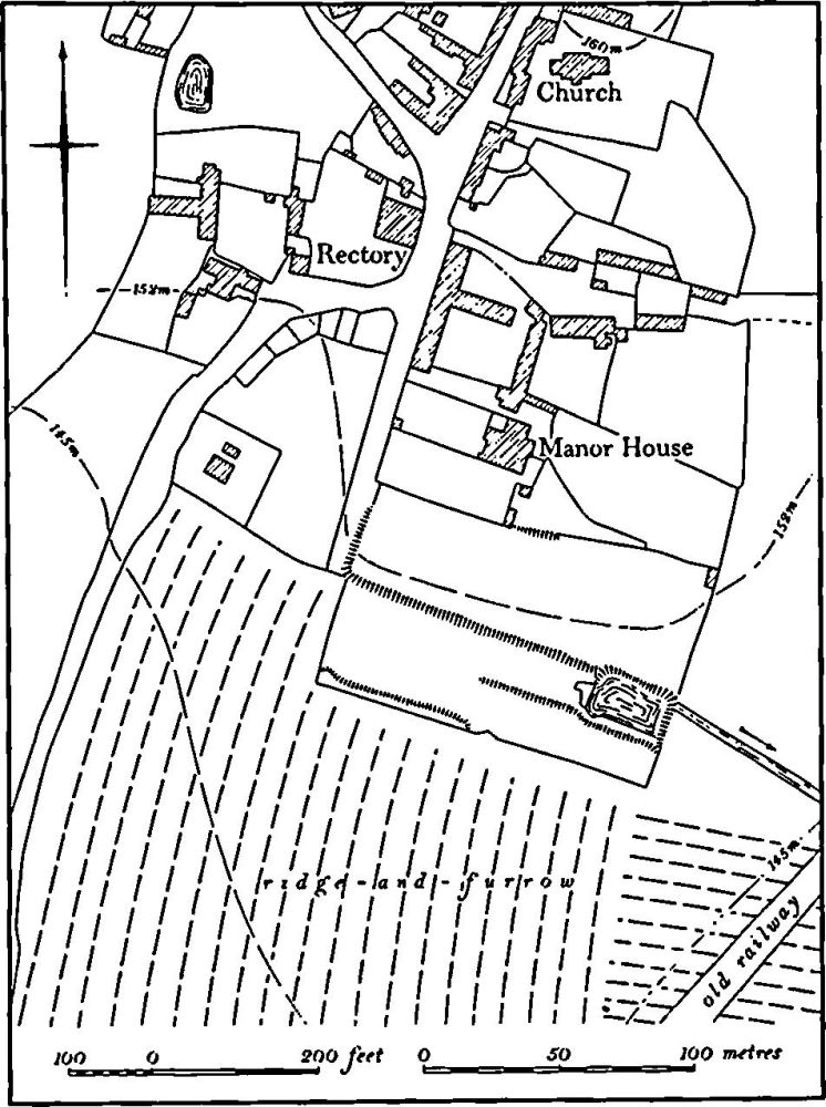
Fig. 63 Greatworth (9) Site of manor house and garden
a(10) Deserted Village of Stuchbury (SP 569440; Figs. 61 and 64), lies in the N. of the parish, between 160 m. and 137 m. above OD. It is situated on the N. side of a broad valley cut into Upper Lias Clay with, on the higher slopes, limestone overlaid in places by Boulder Clay. As a result of this formation springs break out around the site, producing very marshy ground. Various attempts at drainage both in antiquity and in recent times have resulted in a considerable number of ditches and the partial destruction of the remains of the village.
The village had its own lands and field system (Fig. 61), the boundaries of which are shown on maps of 1634 and 1845 (NRO), and was once an independent parish with its own church dedicated to St. John.
Stuchbury is first mentioned in 1086 when Domesday Book lists it as a single manor of two hides with a recorded population of 13 (VCH Northants., 1 (1902), 344). Twenty-one people paid the Lay Subsidy of 1301 (PRO, E179/155/31) and Stuchbury is mentioned by name in the Nomina Villarum of 1316. The village paid 31s. 4d. for the Lay Subsidy of 1334 (PRO, E179/155/3) and in 1377 59 people over the age of 14 paid the Poll Tax (PRO, E179/ 155/28) but by 1674 only four householders paid the Hearth Tax (PRO, E179/254/14). Bridges, writing in about 1720 (Hist. of Northants., I (1791), 201), said there were only four houses at Stuchbury but three of these would probably be the farms of Stuchbury Manor, Stuchbury Lodge and Stuchbury House which still exist and it is likely that by then only the present Stuchbury Hall remained on the village site. By 1801 30 people lived in the general area.
The village was held by St. Andrew's Priory in Northampton until the Dissolution and it is likely that the priory cleared the village for sheep at some time after 1377. It was certainly depopulated by the early 16th century for no houses or tenants are mentioned when two closes called West Field and Town Field were let. In 1547 1000 sheep were being grazed there (K. J. Allison et al., The Deserted Villages of Northants. (1966), 46).
The remains of the village are poorly preserved as a result of later ploughing and drainage-works but its general layout can be ascertained. The main street seems to have been the lane which runs S. from Stuchbury Hall ('a'-'b' on plan) which is deeply hollowed over much of its length. At its N. end ('a' on plan) this street divided into two or three tracks. One ran N.W. and then N. towards Sulgrave generally along the line of the existing farm track and part of the hollowed S.E. end of this is still visible N.E. of the hall ('c' on plan). Another ran N.E. and its line is marked by an irregular shallow hollow-way ('d' on plan), now blocked at its N. end. A third track probably ran S.E. down the valley side ('e' on plan) where there are traces of a hollow-way, though its junction with the other tracks is obscured by later disturbance.
Houses apparently lay on each side of the main street ('a'-'b' on plan). On the E. the present lane is edged by low earthworks comprising shallow rectangular depressions, probably former house-sites, bounded by low scarps and banks nowhere above 0.5 m. high. Less well-preserved earthworks lie on the W. side of the lane, S. of the hall. Further W. lie three formerly rectangular ponds, now reduced to marshy depressions ('f', 'g' and 'h' on plan) as well as a number of drainage ditches, low scarps and shallow quarries. Only one of the ponds ('g' on plan) is shown on the Tithe Map of 1845 (NRO); the area was then known as Horse Close.
In the N.E. corner of the site, around the hollow-way ('d' on plan), there are numerous large depressions of no particular form. This land has recently been drained and ploughed and the surviving earthworks are impossible to interpret, but local tradition asserts that the parish church stood here.
Medieval pottery of 13th and 14th-century date has been found in a modern drain at the N. end of the site and more is said to have been discovered during earlier drainage-work in the S.E. corner. In addition Saxon pottery has been recovered somewhere in the area (CBA Group 9, Newsletter, 6 (1976), 29). On the edge of the site, in the valley bottom, is a group of fishponds (11) which were presumably contemporary with the village. (RAF VAP CPE/ UK/1926, 1216–7; CPE/UK/1994, 1029–31; CUAP, SA31–2, AGV28)
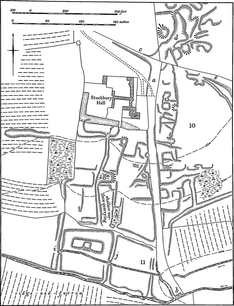
Fig. 64 Greatworth (10) Deserted village of Stuchbury, (11) Fishponds
a(11) Fishponds (SP 568438; Fig. 64), lie in the valley of a small E.-flowing stream immediately S. of the deserted village of Stuchbury (10), on Upper Lias Clay at 138 m. above OD. The stream now flows in an embanked leat on the S. side of the valley, with the remains of two or three ponds to the N. The W. pond is now identifiable only by its dam ('i' on plan) which consists of a bank 1 m. high, spanning the valley, with a shallow ditch on its W. side from which the material to construct the dam was obtained. The central pond is better defined, with low scarps on the N. and S. and a low bank or dam only 1 m. high at its E. end ('j' on plan). Within this pond, towards its N. edge, are two raised platforms only 0.5 m. high, joined by low banks. These may have been islands in the pond, but if so they would have been very close to the water-level when the pond was full and the depressions between the banks would have been below the water-level. There may have been a third pond to the E., again bounded by low scarps on the N. and S. and by a possible dam at its E. end. The latter is now only a slight limestone-rubble bank, less than 0.5 m. high. It is used as a track across the valley and may originally have been an embanked track rather than a dam. (RAF VAP CPE/UK/1926, 1216–7; CUAP, SA31, AGV28)
a(12) Deer Park (?) (centred SP 560422; Fig. 61), probably lay S.E. of Greatworth village, on Boulder Clay, limestone and clay between 130 m. and 137 m. above OD. The park is ill recorded in documents, but certainly existed in the mid 13th century (Northants P. and P., 5 (1975), 225) when it was said to be in Halse. A small copse called Park Spinney (SP 554417) and a single field to the N.E. called the Park on the Tithe Map of Greatworth (1845, NRO) provide the only clue to the location of the deer park. No trace remains on the ground of any boundaries, but there are streams along most of its circuit. Elsewhere only low hedge banks are visible. Ridge-and-furrow of normal medieval form is traceable within this assumed park. (RAF VAP CPE/UK/1926, 1215–6)
a(13) Deserted Village of Halse (SP 566404; Figs. 61 and 65), lies in the S. of the parish, around the source of a small W.-flowing stream, on limestone between 135 m. and 155 m. above OD. Halse was once an independent parish the boundaries of which can still be identified (Fig. 61).
Halse is first mentioned in Domesday Book where it is listed as a single manor gelding for two hides and held by Earl Aubrey together with parts of Brackley and Syresham (VCH Northants., I (1902), 330). Because of the wording of Domesday Book it is impossible to ascertain the population of Halse at this time. The link between Old Brackley (Brackley (3)) and Halse remained throughout medieval and later times and probably originated from the fact that Old Brackley was once a chapelry of Halse. The 1301 Lay Subsidy records 30 taxpayers at Halse (PRO, E179/155/ 31) but it is likely that Old Brackley is included in this figure, as it certainly is in the 1334 Lay Subsidy when the two places together paid 67s. 3d. (PRO, E179/155/3). This sum is large, however, perhaps suggesting that Halse was still of considerable size at this time. In 1377 107 people at Halse over the age of 14 paid the Poll Tax (PRO, E179/ 155/27), again a large number but again probably including Old Brackley. Thereafter no firm indication of the size of Halse is recorded until the early 18th century when Bridges (Hist. of Northants., I (1791), 153) said it was a hamlet of nine houses. It remained the same size until the early 19th century for Baker (Hist. of Northants., I (1822–30), 586) also recorded nine houses there, and by the late 19th century only two farms and three houses stood on the site of the village though one other farm and three other houses lay nearby. This was the situation until recent years but a large number of new houses (not shown on plan) have now been erected in the area between Manor Farm and Halse Grange. The village of Halse had a church or chapel dedicated to St. Andrew (A. Green, Hist. of Brackley (1869), 27).
To judge from the pattern of the surrounding ridge-and-furrow the village was probably situated around Manor Farm, though nothing remains on the ground apart from some slight scarps around a pond cut deeply into the rising ground N. of the farm ('a' on plan). The traditional site of the parish church is said to be at or near Manor Farm and it is recorded that in 1912–13 many skeletons were discovered during alterations to the buildings N.W. of the farmhouse (local inf.). Some fragments of late medieval window tracery are built into the garden wall and an octagonal basin, perhaps a late medieval font, also survives in the garden. A few sherds of medieval pottery are recorded from the area (Northants. Archaeol., 10 (1975), 167).
Surviving earthworks lie in a broad are S.W., S. and S.E. of Manor Farm but, though clearly related to the village, these are not part of the settlement area. Immediately S. of the farm, in the valley of a stream ('b' on plan), are three rectangular fishponds. The upper, northern one is still filled with water and has traces of a dry-stone revetment on its W. side. It has probably been altered in postmedieval times. The central pond is now dry and the original dam at its S. end is broken through. The third and largest pond, also now dry, is cut back up to 2 m. into the valley sides but only part of the dam at its W. end survives. The water in this pond was apparently supplemented by two catchment drains ('c' and 'd' on plan) which, though reused in modern times, appear to have carried water from adjacent springs.
The main earthworks in the area are a complex system of hollow-ways. The main one is first visible in the S.E. ('e' on plan) as a slightly hollowed feature running S.W. After 60 m. it divides and a branch probably ran N.W. towards Manor Farm, though it now only exists as a narrow gap between the ridge-and-furrow to the N.E. and a bank up to 1 m. high on the S.W. The main hollow-way continues S.W. with two marked curves in its alignment. At its W. end it is cut down 1.75 m. below ground level to the S. and has an almost continuous bank 0.5 m. high on its N. side. This hollow-way meets another at right angles ('f' on plan); the latter runs N.W. until it reaches the stream where it fades out. It apparently once crossed the stream for its continuation, still a broad hollow-way, climbs the opposite hillside and then forks ('g' on plan). The N.W. branch divides again to the N.W., W. and S., apparently to give access to the adjacent ridge-and-furrow, while the main hollow-way continues until it meets the field boundary where it stops abruptly. However, it probably once continued N., for another hollow-way is visible to the N. ('h' on plan) running N.W. to meet a further hollowed trackway which crosses the area from S.W.-N.E. ('i' on plan). (RAF VAP CPE/UK/1926, 5214–6; CUAP, LD72, NU97, SA26, ANZ3; air photographs in NMR)
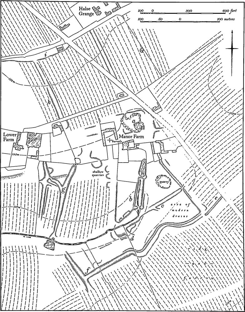
Fig. 65 Greatworth (13) Deserted village of Halse
(14) Cultivation Remains (Fig. 61). The common fields of Greatworth were enclosed by agreement in 1634 (NRO, Enclosure Agreement), but nothing is known of their arrangement. Ridge-and-furrow exists on the ground or can be traced on air photographs over much of the land attributable to Greatworth though it survives best on the lower clay areas in the S.W. of the parish. It is arranged in end-on and interlocked furlongs, many of reversed-S form. To the S. of the village (SP 550418) are runs of end-on furlongs either with deeply hollowed tracks or, in one case, with a modern lane passing between them. Here the ridges terminate on the edges of the tracks in large rounded mounds up to 0.5 m. high.
The date of the enclosure of the common fields of the deserted village of Stuchbury (10) is unknown, but had taken place before the middle of the 16th century when sheep were being grazed within large closes there. It is likely that enclosure took place after 1377 as the village had not been depopulated by that date (K. J. Allison et al., The Deserted Villages of Northants. (1966), 46). Ridge-and-furrow of these fields exists on the ground or can be traced on air photographs over much of the area of land which is attributable to Stuchbury, arranged mainly in rectangular interlocked furlongs. However, modern cultivation has removed much of the generally slight remains except in the clay-floored valley in the S.
The date of the enclosure of the common fields of the deserted village of Halse (13) is also unknown but appears to have been before 1634 (NRO, Enclosure Agreement of Greatworth). Ridge-and-furrow of these fields can be traced in a number of places on air photographs but little now remains on the ground. It is arranged in end-on and interlocked furlongs, many of reversed-S form. To the N.N.E. of the village (SP 567412) there was formerly an unusual arrangement of ridge-and-furrow around the head of a broad W.-facing combe. Here the ridges radiated outwards up the slope in a fan-shaped pattern with the ridges narrowing from 7 m. wide at the top of the slope to under 3 m. near the valley bottom. In the same area there was evidence of overploughing of earlier headlands which produced long ridges of double reversed-S form. (RAF VAP CPE/UK/1926, 1215–9, 2215–7, 3214–9, 5213–8; CPE/UK/1994, 1028–31)
Undated
(15) Burials (?) (unlocated). At some time before 1712 the discovery was made, during stone-quarrying somewhere in Greatworth parish, of a row of five urns with a smaller vessel inverted in the mouth of one of them; no other information is available (J. Morton, Nat. Hist. of Northants. (1712), 530).
