An Inventory of the Historical Monuments in the County of Northamptonshire, Volume 3, Archaeological Sites in North-West Northamptonshire. Originally published by Her Majesty's Stationery Office, London, 1981.
This free content was digitised by double rekeying. All rights reserved.
'Marston Trussell', in An Inventory of the Historical Monuments in the County of Northamptonshire, Volume 3, Archaeological Sites in North-West Northamptonshire( London, 1981), British History Online https://prod.british-history.ac.uk/rchme/northants/vol3/pp137-142 [accessed 27 November 2024].
'Marston Trussell', in An Inventory of the Historical Monuments in the County of Northamptonshire, Volume 3, Archaeological Sites in North-West Northamptonshire( London, 1981), British History Online, accessed November 27, 2024, https://prod.british-history.ac.uk/rchme/northants/vol3/pp137-142.
"Marston Trussell". An Inventory of the Historical Monuments in the County of Northamptonshire, Volume 3, Archaeological Sites in North-West Northamptonshire. (London, 1981), , British History Online. Web. 27 November 2024. https://prod.british-history.ac.uk/rchme/northants/vol3/pp137-142.
In this section
46 MARSTON TRUSSELL
(OS 1: 10000 a SP 68 SE, b SP 68 NE, c SP 78 NW)
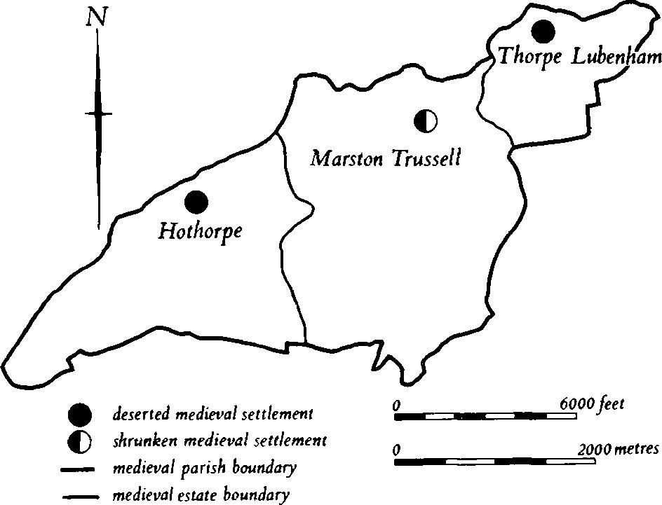
The parish is roughly triangular, covering some 1400 hectares, and lies against the R. Welland which here forms the boundary with Leicestershire. Most of the area is on river gravel or alluvium at about 100 m. above OD, with Lower and Middle Lias Clay exposed as the land rises steeply in the S., up the N. scarp of the Hothorpe Hills, to 160 m. above OD. There is considerable evidence for prehistoric and Roman occupation in the area; the Roman sites (1–5) occur both close to the R. Welland and on the higher ground to the S. The parish is also notable for its medieval remains which are associated with three distinct settlements and their land units (Fig. 106). The villages of Hothorpe (9) and Thorpe Lubenham (8) are both now deserted and at Marston Trussell itself (6) there are earthworks of former settlement which reflect considerable change perhaps of relatively recent date.

Fig. 106 Marston Trussell Medieval settlements and estates
Prehistoric and Roman
A small bronze dagger of middle Bronze Age type was found in the parish in 1845 (NM; T. J. George, Arch. Survey of Northants. (1904), 17).
a(1) Iron Age and Roman settlement (SP 676841), lies on the N. slope of the Hothorpe Hills, on clay at 120 m. above OD. Roman pottery has been found, as well as some Iron Age sherds (Northants. Archaeol., 10 (1975), 157).
a(2) Iron Age and Roman settlement (?) (SP 688840), in a position similar to (1) but 1 km., to the E. Iron Age and Roman sherds have been discovered (Northants. Archaeol., 12 (1977), 213).
b(3) Roman building (SP 69318592), lies in the E. of the village, around the church, on clay and alluvium at about 94 m. above OD. During alterations to the church and the rectory in either the late 19th or early 20th century many Roman finds were made, including samian and Nene Valley ware, tesserae and tiles. More tesserae, tiles and pottery, as well as Roman coins, were later discovered during grave-digging and restoration of the church in 1945, and when new houses were built opposite the church in the 1950s a very large amount of Roman pottery, including samian and an almost complete 3rd-century flagon, was found (SP 69318601). A large Roman building or settlement is indicated (JRS, 16 (1926), 223; OS Record Cards; NM; Market Harborough Museum).
c(4) Roman settlement (?) (SP 702860), lies S.W. of Thorpe Lubenham Hall, on clay and alluvium at 90 m. above OD. Roman pottery has been found in this area (Northants. Archaeol., 10 (1975), 157).
c(5) Roman settlement (?) (SP 712867), lies in the E. of the parish, on the W. side of a small hill close to the R. Welland, on alluvium at about 90 m. above OD. A scatter of Roman pottery has been found in this area (OS Record Cards; Market Harborough Museum).
Medieval and Later
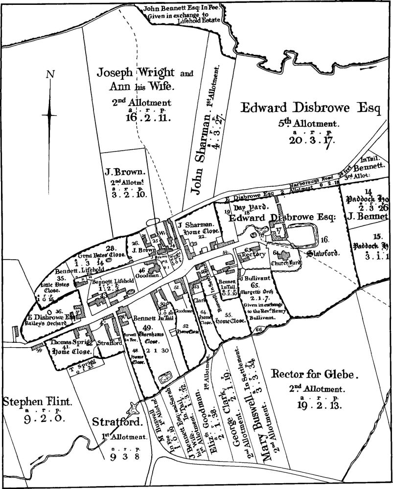
b(6) Settlement remains (centred SP 691855; Figs. 106, 107 and 108), formerly part of Marston Trussell, lie in and around the existing village, on river gravel and Lower Lias Clay at around 98 m. above OD. Marston Trussell today is the result of extensive 19th-century alterations associated with emparking and relocation of the manor house, and it is not clear what the earlier form of the village was. From the earliest large-scale map (NRO, Enclosure Map, 1815; Fig. 108) and the surviving earthworks, it is possible to suggest that the medieval village lay along an E.–W. road, now the main street, running between Hothorpe (9) to the W. and East Farndon to the E., perhaps with a back lane to the N. The church and the moated manor house (7) lay at the E. end of this street. At some unknown date a new manor house, with associated paddocks, was built N. of the church and W. of the moat. The E. end of the main street thus became a cul-de-sac leading only to the church and manor house; through traffic turned N. in the centre of the village and then passed along the original back lane E. towards East Farndon. One other road, from Sibbertoft to the S., joined the main street near its W. end. This is the layout shown on the Enclosure Map of 1815, except that the road to East Farndon had been abandoned and a new road had been cut across the fields towards Thorpe Lubenham N.W. from the end of the back lane.
No change occurred from 1834, when the village is depicted on the 1st ed. OS 1 in. map, until perhaps a little before 1874 when a number of unconnected events took place. First the old manor house was demolished and the present road to Thorpe Lubenham was cut across part of its site, from near the church to the beginning of the enclosure road to the N.E. This resulted in the abandonment of the back lane. Secondly the major landowners, the Bennet family, enlarged their existing house at the W. end of the village and this became the present Marston Trussell Hall. They demolished buildings on either side of the house to form a garden, cleared three farms to the S. and stopped up the Sibbertoft road in order to create the park and lake. They also recut the Sibbertoft road further E. At the same time, or slightly later, many of the houses in the village were rebuilt (Whellan, Dir., 836–7).
The physical remains of these changes can be seen in two places. To the N. of the main street, behind the present houses, the old back lane survives as a shallow hollow-way with old property boundaries in the form of low scarps and banks running S. from it. To the S. of Marston Trussell Hall, within the park but now under cultivation, is an area of uneven ground with extensive spreads of stone and gravel as well as pottery, mainly of post-medieval date. A considerable amount of medieval pottery, bones and an iron arrowhead were found, as well as some Roman material (3), on a building site N.W. of the church in 1952 (SP 692859; OS Record Cards; CUAP, AHE78–9).

Fig. 107 Marston Trussell (6) Settlement remains, (7) Moat
b(7) Moat (SP 694859; Figs. 107 and 108), lies at the E. end of the village of Marston Trussell, immediately N.E. of the church, on Lower Lias Clay and river gravel at 94 m. above OD. It is presumably the site of the medieval manor house of the village which was later replaced by a large building arranged round a central courtyard. This house and the moat are both shown on the Enclosure Map of 1815 (NRO; Fig. 108). The moat consists of a wide ditch, now dry, up to 2 m. deep, surrounding a small square island which is level with the adjacent ground. It appears to have been filled by seepage from a spring in its N.W. corner. The S.W. corner has been encroached upon by the churchyard wall. The moat is surrounded by a number of embanked and ditched enclosures, with other small indeterminate earthworks to the S., which probably represent manorial paddocks (CUAP, AHE78–9).

Fig. 108 Marston Trussell (6, 7) Plan of village in 1815 (from Enclosure Map in NRO)
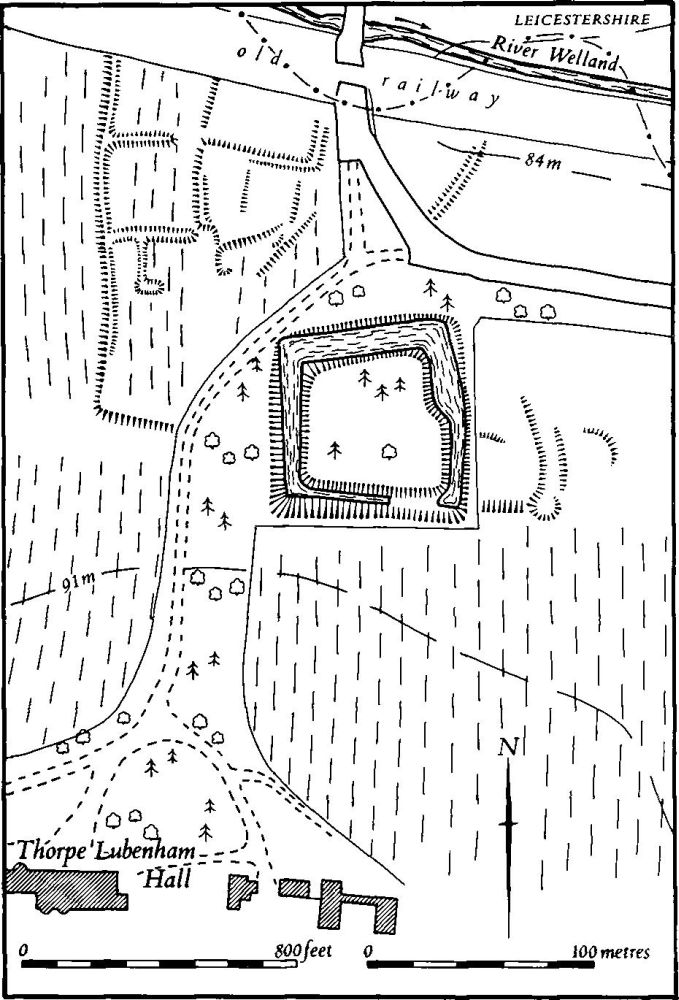
c(8) Settlement remains and manor house site (SP 70508682; Figs. 106 and 109), formerly part of the hamlet of Thorpe Lubenham, lie in the N.E. corner of the parish, on the S. side of the R. Welland, on river gravel at 85 m. above OD. The hamlet was the centre of a land unit which was quite separate from that of Marston Trussell, the boundaries of which are shown on the Enclosure Map of 1815 (NRO; Fig. 106). The settlement is first noted in Domesday Book, but is listed with Marston Trussell and no individual population figures are recorded (VCH Northants., II (1906), 330). Although the village was always apparently in Northamptonshire, its name and the fact that is was a chapelry of Lubenham, N. of the R. Welland in Leicestershire, suggests that it was originally a secondary settlement of Lubenham. Thorpe Lubenham is mentioned separately in the 1316 Nomina Villarum, but in 1334 it only paid 12s. tax for the Lay Subisdy, a very small sum and much less than was paid by many other villages in the county which were also later deserted (PRO, E179/155/3). In 1377 only 27 people over the age of 14 paid the Poll Tax, again a low figure (PRO, E179/155/27). During the 15th century the manor passed to non-resident heiresses and by 1547 600 sheep were grazed on the lordship. Only one household, presumably the manor house, paid the Hearth Tax of 1674 (PRO, E179/254/14) and Bridges (Hist. of Northants., II (1791), 50) recorded a single manor house there in about 1720. This house was demolished in the late 18th century and the present hall was erected to the S. (K. J. Allison et al., The Deserted Villages of Northants. (1966), 46).
The main feature of the site is the moat of the manor house. This consists of a broad water-filled ditch 2 m. deep, surrounding a level, roughly square island. In the N.W. corner are a number of small depressions, the result of minor excavations in 1955–6, but the latter revealed nothing more than fragments of late medieval brick, tile, pottery and glass (OS Record Cards) and similar material has been found on the surface. A house stood on the island until the later 18th century. An engraving published at that time (J. Nichols, Hist. of Leics., II (1798), 701, 710) shows the building as T-shaped in plan, of timber-framed construction and perhaps of 16th or 17th-century date. Outbuildings lay to the E. and W.
N.W. of the moat, on the opposite side of the present drive to the hall, is a small area of earthworks bounded on the W. and S.W. by a low scarp and consisting of a series of small irregular enclosures. The fact that these have been over-ploughed by very slight ridge-and-furrow makes interpretation difficult, but there is no reason to doubt that they are the remains of the hamlet of Thorpe Lubenham.
To the N. across the county boundary are other slight earthworks. These are the remains of closes and ponds which were still in use in the early 19th century (Map of Lubenham, 1816, in Lubenham Church; CUAP, AHE77).

Fig. 109 Marston Trussell (8) Settlement remains and site of manor house at Thorpe Lubenham
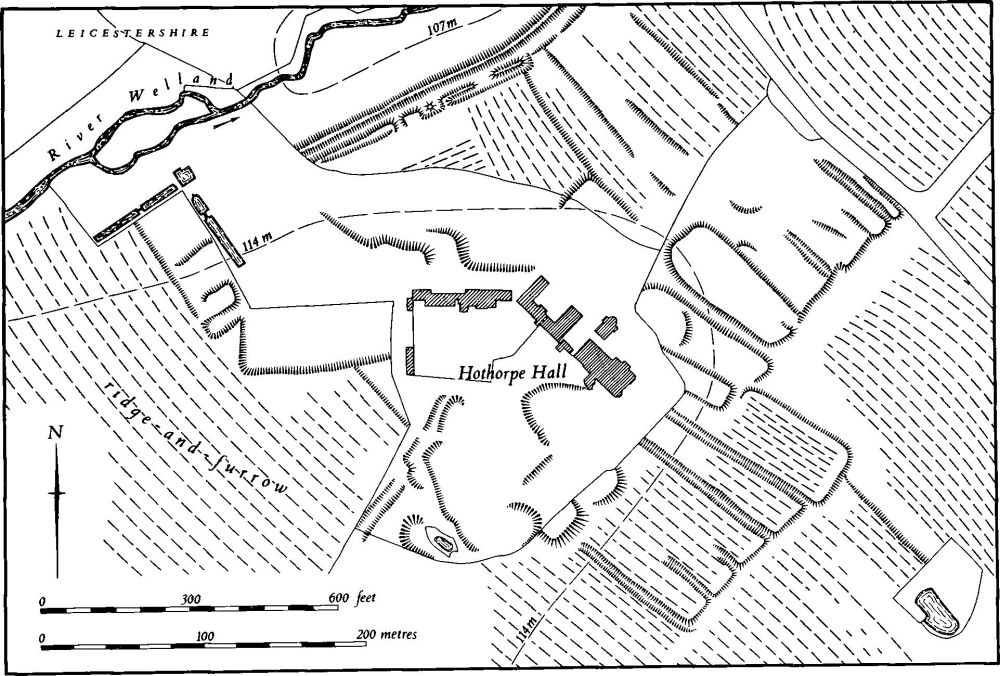
b(9) Deserted village of Hothorpe (SP 667852; Figs. 106 and 110), lies in the W. of the parish, on river gravel, Boulder Clay and Lower Lias Clay at 115 m. above OD. The village had its own land unit, the E. boundary of which is shown on the Enclosure Map of Marston Trussell of 1815 (NRO; Fig. 106). In medieval times it was a chapelry of Theddingworth, the village immediately to the N., across the R. Welland, in Leicestershire. Hothorpe is first recorded in 1086 when it consisted of 3½ virgates of sokeland with one sokeman, held by the Abbey of Bury St. Edmunds (VCH Northants., II (1906), 318). However, the place is listed by name in the Nomina Villarum of 1316, and by 1334 paid 36s. 4d. for the Lay Subsidy (PRO, E179/155/3). By 1377 a total of 57 people over the age of 14 paid the Poll Tax (PRO, E179/155/27) and even in the early 18th century Bridges (Hist. of Northants., II (1791), 37) said that there were about 20 houses there. In 1801 the present Hothorpe House was built, and in about 1830 the owner removed what remained of the village, rehoused the inhabitants in Theddingworth and laid out the park which surrounds the house. This work is shown as completed on an Estate Map of 1832 (NRO; K. J. Allison et. al., The Deserted Villages of Northants. (1966), 41; M. W. Beresford, The Lost Villages of England (1954), 367).
The surviving remains are very fragmentary, as is usual in villages deliberately cleared at a late date, and little remains N., W. and S.W. of the hall apart from some indeterminate scarps. To the S.E. and E. of the hall, however, a more regular pattern of long closes is visible, bounded by low scarps, and this may therefore have been a part of the village already deserted before the early 19th century, the deliberate clearance involving only houses in the immediate vicinity of the hall (CUAP, AUB17, BAP63).

Fig. 110 Marston Trussell (9) Deserted village of Hothorpe
(10) Cultivation remains. The common fields of the old parish of Marston Trussell were enclosed by an Act of Parliament of 1813 (NRO, Enclosure Map, 1815; Fig. 108). Before that date there were three named fields, Mill Field in the N., Threeway Field in the S.W. and Pitway Field in the S.E. A long narrow strip of meadow lay between a stream and the S. half of the E. boundary. Old enclosures existed around and to the E. of the village, and in part of the now wooded area of the Hothorpe Hills (SP 691835); there was also a small area of them along the R. Welland (SP 679859). These fields were apparently already enclosed in the early 18th century according to Bridges (Hist. of Northants., II (1791), 50). Ridge-and-furrow of the common fields remains on the ground or can be seen on air photographs over most of the land attributable to Marston Trussell. To the S., on the higher more broken ground, it is arranged across the spurs and in radiating furlongs running down the slopes. Elsewhere, on the lower, flatter ground, most of it is interlocked. It remains in good condition in a number of places, most notably around the village.
The date of enclosure of the common fields of Thorpe Lubenham (8) is unknown but was certainly before the mid 16th century and perhaps as early as the 15th century. Ridge-and-furrow of these fields can be traced over most of the land of the settlement, arranged in interlocked furlongs. It is well preserved in the pasture around Thorpe Lubenham Hall.
The common fields of Hothorpe (9), also, were enclosed at an unknown date. Large areas of ridge-and-furrow, arranged in end-on and interlocked furlongs, still exist in the parkland around the hall, but elsewhere it is mainly now ploughed out (RAF VAP 106G/UK/636, 3132–3, 4131–40).
