An Inventory of the Historical Monuments in the County of Northamptonshire, Volume 2, Archaeological Sites in Central Northamptonshire. Originally published by Her Majesty's Stationery Office, London, 1979.
This free content was digitised by double rekeying. All rights reserved.
'Yardley Hastings', in An Inventory of the Historical Monuments in the County of Northamptonshire, Volume 2, Archaeological Sites in Central Northamptonshire( London, 1979), British History Online https://prod.british-history.ac.uk/rchme/northants/vol2/pp182-186 [accessed 23 November 2024].
'Yardley Hastings', in An Inventory of the Historical Monuments in the County of Northamptonshire, Volume 2, Archaeological Sites in Central Northamptonshire( London, 1979), British History Online, accessed November 23, 2024, https://prod.british-history.ac.uk/rchme/northants/vol2/pp182-186.
"Yardley Hastings". An Inventory of the Historical Monuments in the County of Northamptonshire, Volume 2, Archaeological Sites in Central Northamptonshire. (London, 1979), , British History Online. Web. 23 November 2024. https://prod.british-history.ac.uk/rchme/northants/vol2/pp182-186.
In this section
67 YARDLEY HASTINGS
(OS 1:10000 a SP 85 SW, b SP 85 SE, c SP 85 NW, d SP 85 NE)
The roughly rectangular parish, covering about 1460 hectares, lies against the county boundary with Bedfordshire which forms its S.E. side. It consists of land sloping generally N. between 110 m. and 66 m. above OD, and is entirely on Boulder Clay except where the down-cutting of a number of N.-flowing streams has exposed narrow bands of limestones and silts along their valley sides. Many prehistoric and Roman sites are recorded, most of which are on the higher Boulder Clay areas and have been discovered as a result of intensive field-walking.
Prehistoric and Roman
A polished stone axe was found in the parish in the 19th century (JBAA, 29 (1873), 304; lost), and a flint axe in 1966 (at SP 875581). A Roman coin was found before 1900 (NM Records).
d(1) Cropmarks (SP 856553), on Boulder Clay at 107 m. above OD. Cropmarks of unknown form are said to exist here (NM Records).
d(2) Enclosure (SP 850551), 700 m. W.S.W. of (1) in a similar situation. Air photographs (in NMR) show very indistinctly what appear to be the S. halves of two concentric enclosures about 110 m. and 40 m. in diam. A ditched trackway, 10 m. –15 m. wide, running E.—W., touches the S. side of the outer enclosure, and is traceable for some 200 m.
d(3) Enclosures and Iron Age Settlement (SP 859552; Fig. 162), 200 m. S.E. of (1) in a similar situation. Air photographs (in NMR) show a group of small conjoined enclosures. A large area of dark soil containing stone, iron slag and Iron Age pottery has been found at the site (BNFAS, 6 (1971), 19, Yardley Hastings (14).

Fig. 162 Yardley Hastings (3) Cropmarks, (21) Iron Age and Roman settlement
d(4) Iron Age Site (?) (SP 868556), 500 m. N.W. of The Pastures, on Boulder Clay at 99 m. above OD. A few sherds of Iron Age pottery, associated with an area covered by iron slag, have been found (BNFAS, 6 (1971), 19, Yardley Hastings (11)).
b(5) Iron Age Site (?) (SP 866536), in the extreme S.E. of the parish, on Boulder Clay at 110 m. above OD. Iron Age pottery has been found in this area (BNFAS, 4 (1970), 6; 6 (1971), 20, Yardley Hastings (20)).
d(6) Iron-Working Site (?) (SP 860578), N.W. of the village, on Boulder Clay at 91 m. above OD. A patch of iron slag, similar to those usually associated with Iron Age pottery, has been noted here (BNFAS, 6 (1971), 19, Yardley Hastings (4)).
d(7) Roman Settlement (?) (SP 876591), in the extreme N. of the parish, on limestone at 80 m. above OD. Roman material is recorded from this site (BNFAS, 1 (1966), 8, listed under Grendon; 6 (1971), 19, Yardley Hastings (1)).
d(8) Roman Settlement (?) (SP 870589), 300 m. S.W. of (7) in a similar position. Roman material is recorded (BNFAS, 1 (1966), 14; 6 (1971), 19, Yardley Hastings (2)).
d(9) Iron Age and Roman Settlement and Kiln (?) (SP 874581), found in a sandpit at 70 m. above OD. In 1968 some late Iron Age and much 1st and 2nd-century Roman pottery, kiln bars and an iron sickle were discovered here as well as traces of ditches and pits. A stone-lined well, 4.7 m. deep, was excavated and found to contain Roman pottery and animal bones. An inhumation burial was also recorded as well as worked flints and the remains of a leather sole (BNFAS, 4 (1970), 14–15; 6 (1971), 19, Yardley Hastings (3); OS Record Cards).
d(10) Roman Settlement (SP 853571), in the W. part of the parish, on Boulder Clay at 94 m. above OD. Roman pottery, including samian and colour-coated wares, has been found, associated with a scatter of stone and tiles. A fragment of a quern has also been found (BNFAS, 6 (1971), 19, Yardley Hastings (6)).
d(11) Roman Settlement (SP 876572), E. of the village, on Boulder Clay at 91 m. above OD. Roman pottery, as well as a coin of Hadrian, have been found (BNFAS, 6 (1971), 19, Yardley Hastings (5)).
d(12) Roman Settlement (SP 875562), S.E. of the village, on Boulder Clay at 100 m. above OD. Roof tiles, iron slag and Roman pottery, including samian, have been found, associated with patches of stone (BNFAS, 1 (1966), 14; 6 (1971), 19, Yardley Hastings (7)).
d(13) Roman Settlement (?) (SP 871560), 400 m. S.W. of (12), on Boulder Clay at 105 m. above OD. A large area of stones, with Roman pottery, has been noted (BNFAS, 6 (1971), 19, Yardley Hastings (8)).
d(14) Roman Settlement (?) (SP 873557), 350 m. S.S.E. of (13) in a similar position. A small quantity of Roman pottery has been found (BNFAS, 6 (1971), 19, Yardley Hastings (9)).
d(15) Roman Settlement (SP 876556), 600 m. S.E. of (13), on Boulder Clay at 105 m. above OD. Roman pottery, including samian, fragments of roof tiles, unidentified iron objects, part of a quern and two coins have been found near an area of limestone rubble (BNFAS, 1 (1966), 14; 6 (1971), 19, Yardley Hastings (10); OS Record Cards).
d(16) Iron Age and Roman Settlement (centred SP 853555; Fig. 163), S.W. of the village, on Boulder Clay at 104 m. above OD. Discoveries made over a number of years indicate an area of occupation covering six hectares. Finds and features include:

Fig. 163 Yardley Hastings (16) Iron Age and Roman settlement
(a) at SP 853554, a series of irregular cropmarks, visible on air photographs (in NMR), which may represent a series of overlapping and conjoined enclosures. These seem to be associated with an area of dark soil from which have come large stones, part of a saddle quern, a quantity of Iron Age pottery and a few Roman sherds (BNFAS, 3 (1969), 6; 6 (1971), 19–20, Yardley Hastings (17)).
(b) at SP 852557, 1st-century Roman pottery, including samian, and part of a quern, with a scatter of stones (BNFAS, 6 (1971), 19–20, Yardley Hastings (15)).
(c) at SP 853557, Roman pottery, including samian, within an area of dark soil (BNFAS, 6 (1971), 19, Yardley Hastings (16)).
b(17) Roman Settlement (?) (SP 859547), on the edge of Arniss Copse, on Boulder Clay at 110 m. above OD. Quantities of Roman pottery and part of a quern have been found (BNFAS, 6 (1971), 20, Yardley Hastings (18)). More Roman pottery has been discovered 200 m. to the S.E. within the Copse (SP 860545; BNFAS, 2 (1967), 21; OS Record Cards).
a(18) Roman Settlement (?) (SP 847547), immediately N. of The Wold, on Boulder Clay at 106 m. above OD. Air photographs (not seen by RCHM) are said to show cropmarks of a square enclosure, and Roman pottery has been found (NM Records).
a(19) Roman Settlement (SP 843538), S.W. of The Wold, on Boulder Clay at 106 m. above OD. Many Roman sherds, some of the 4th century, and large stones, thought to be part of a road, were found when the area was ploughed during the Second World War (NM Records).

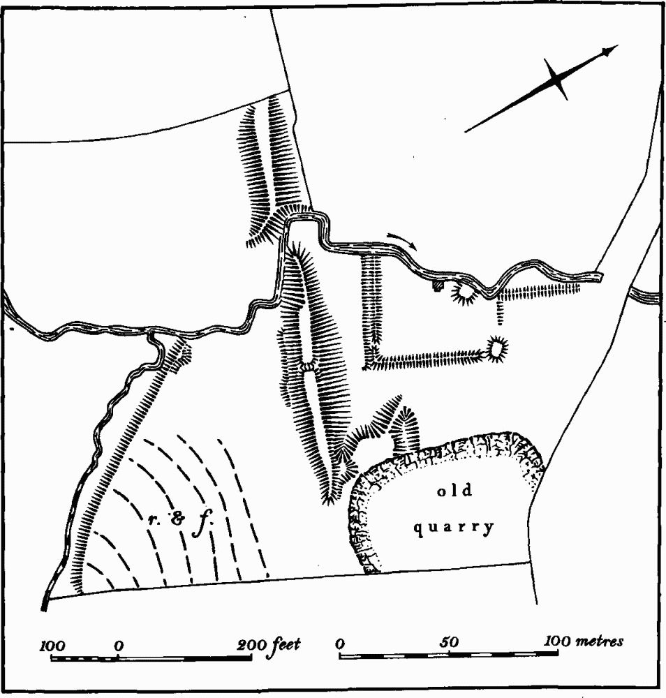
Fig. 164 Yardley Hastings (23) Dam

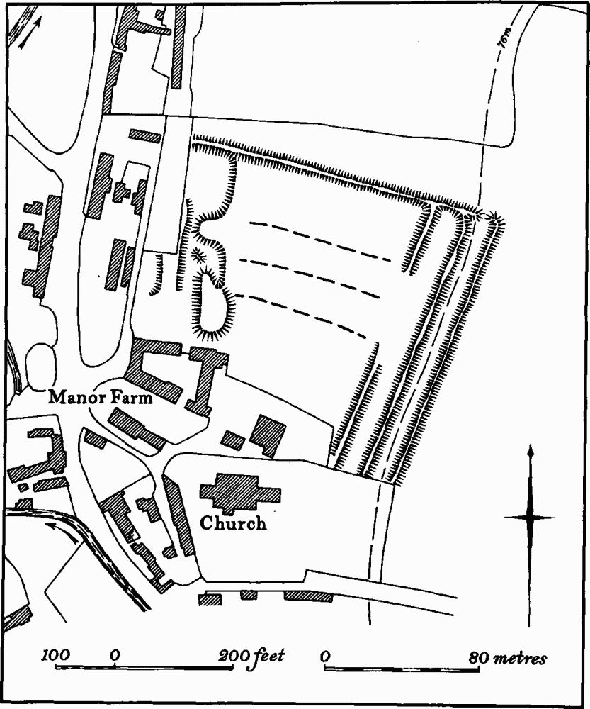
Fig. 165 Yardley Hastings (24) Site of manor house
b(20) Roman Settlement (SP 855529), S.W. of Biggin Lodge, on Boulder Clay at 99 m. above OD, and crossing the county boundary with Buckinghamshire. Much pottery of 4th-century date has been found, over an area of one hectare. A 4th-century coin is also recorded (Northants. Archaeol., 9 (1974), 101). A little to the N. (SP 855532) a small quantity of Roman pottery and one Iron Age sherd have been found (BNFAS, 6 (1971), 20, Yardley Hastings (22)).
d(21) Ring Ditches and Iron Age and Roman Settlement (centred SP 865552; Fig. 162), S. of the village, on Boulder Clay at 104 m. above OD. Various discoveries, made over an area of some 12 hectares, may indicate continuous occupation. The features include:
(a) at SP 86465500, a possible ring ditch, 30 m. in diam., visible on air photographs (in NMR), with a number of other ditches and a small rectangular enclosure. Within the area of the ring ditch and to the E. of it, dark areas of soil with stones and 1st-century pottery, including samian, part of a quern and iron slag have been found (BNFAS, 6 (1971), 19, Yardley Hastings (12)).
(b) at SP 867551, an area of stones associated with worked flints.
(c) at SP 866553 and 862552 Iron Age pottery associated with iron slag.
(d) at SP 863554, much Iron Age and early Roman pottery, worked flints, glass, iron slag, part of a quern and a stone scatter associated with ditches and patches of black soil (NM Records).
(e) at SP 86485535, a ring ditch 22 m. in diam., visible on air photographs (in NMR).
d(22) Roman Pottery (SP 860555), on Boulder Clay at 97 m. above OD. Small quantities of Roman pottery have been found (BNFAS, 6 (1971), 19, Yardley Hastings (13)).
Medieval and Later
A complete St. Neots ware jug is said to have been found in a pit in Ashby Road, Yardley Hastings (SP 86545720; Procs. Cambs. Ant. Soc., 51 (1958), 63; J. Northants. Mus. and Art Gall., 3 (1968), 5; lost).
d(23) Dam (SP 87365836; Fig. 164), across the valley of a N.E.-flowing brook, on Boulder Clay at 64 m. above OD. It consists of a large embankment, 190 m. long, 25 m. wide and up to 3.5 m. high, broken towards the N. end to allow the existing stream to pass through. The date and purpose are not known. It is marked on a map of the parish of 1842 (NRO) and, although it was not shown on an earlier map of 1760 (NRO), the adjacent field was then called 'A Pightle by Dam'. Immediately below the dam is a slightly embanked enclosure. This feature is the remains of an early 20th-century club house and garden belonging to the adjacent derelict golf course (Northants. P. and P., 4 (1971), 310; RAF VAP CPE/UK/1926, 4006–7).
d(24) Site Of Manor House (?) (SP 866571; Fig. 165), in the N.E. of the village, immediately N. of the church and Manor Farm. It consists of a large rectangular enclosure bounded by a low bank up to 1 m. high with similar internal banks at its E. end. At the W. end are irregular platforms and depressions, perhaps the sites of former buildings, and in the centre are three plough ridges (RAF VAP CPE/UK/1926, 4007, 2008, and air photographs in NMR). Fragments of the medieval manor house stand close by (VCH Northants., IV (1937), 296–7) and the earthwork remains may be part of the associated stockyard and gardens. In 1760 a single building stood in the area and this still remained in 1842 (Maps in NRO).
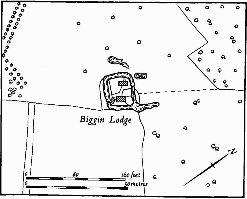
b(25) Moat (SP 858533; Fig. 166), lay around Biggin Lodge, in the far S. of the parish, within a group of fields probably reclaimed from the surrounding woodland in medieval times. It was on Boulder Clay at 110 m. above OD. Nothing is known of its history, but it was probably the site of a medieval farmstead. In 1760 (Map in NRO) the existing farm is shown completely surrounded by an almost square ditch, some 10 m. wide, with two entrances, one on the N. and the other on the S. There was an extension of the ditch beyond the N.E. corner. By 1842 (Map in NRO) this moat had been entirely destroyed except for part of the S.E. side which survived as a pond. This pond still exists.
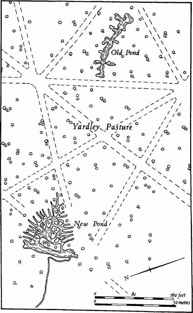
(26) Ponds (Fig. 167). In the S. part of the parish, within the existing woodland or in areas formerly wooded or used as common grazing, are a number of ponds of highly irregular and unusual form. In Old Pond Close (SP 876551) there is one which consists of two narrow parallel channels which meet in the centre where there are short extensions to either side. This is shown on the map of 1760 (NRO). Another pond lies in the centre of Grimsey Copse (SP 866543). It is now cut by a modern ride and consists of two irregular U-shaped ponds. This does not appear on the 1760 map. There are two others to the N.W. of Biggin Lodge, on the edge of woodland (at SP 852535 and 857536), again of irregular form and both of these are shown on the 1760 map. The eastern one was then, and still is called Charcoal Pond. Further N. (at SP 853546) is yet another. This is of square form with two small islands and five irregular projections from it. It is now called Pottosy Pond but in 1760 appears to have been called Pottry Pond. Finally, N. of Old Pond Close, adjacent to the Pastures (SP 873552), are two ponds which existed in 1760 (Fig. 167). One of these is generally T-shaped, with several islands within it and at least twelve projections from it. Two other similar ponds, now altered, existed in the S.W. of the parish (at SP 838549 and 847545). The purpose and date of all the ponds are not known.

Fig. 166 Yardley Hastings (25) Moat (drawing based on plan of 1760)

Fig. 167 Yardley Hastings (26) Ponds (drawing based on plan of 1760)
(27) Cultivation Remains. The common fields of the parish were enclosed by Act of Parliament of 1776. Shortly before that (NRO, Map of 1760) there were five open fields, March, Newey, Ausway, Lower and Round Hey Fields. There were old enclosures all round the village. Around The Pastures (SP 872553), between the fields and the forest, was an area of pasture and scrub, but the woodland, now confined within Eastern Maudit parish on the E. boundary, extended much further into Yardley Hastings parish.
Ridge-and-furrow of these fields can be seen on the ground or from air photographs W. of the village, in the old enclosures around the village, to the S.E. of the village in parts of Round Hey Field and most of March Field, and over most of the land described as scrub and pasture in 1760, indicating earlier cultivation of land later returned to the waste. Around the village it is arranged in end-on furlongs running roughly E.—W. To the S. and E. of the village there are interlocked furlongs. A few blocks of ridge-and-furrow survive elsewhere in the common fields, for example a group of interlocked furlongs in the N. of Round Hey Field, around Dam Hill Furlong (SP 875582; RAF VAP CPE/ UK/1994, 3185–8, 2190–5, 4196–4200; F22 543/ RAF/2409, 0160–1; CPE/UK/1926, 4005–8, 2004–8, 5005–6, 3008–11).
