An Inventory of the Historical Monuments in the County of Northamptonshire, Volume 2, Archaeological Sites in Central Northamptonshire. Originally published by Her Majesty's Stationery Office, London, 1979.
This free content was digitised by double rekeying. All rights reserved.
'Harrowden, Little', in An Inventory of the Historical Monuments in the County of Northamptonshire, Volume 2, Archaeological Sites in Central Northamptonshire(London, 1979), British History Online https://prod.british-history.ac.uk/rchme/northants/vol2/pp81-83 [accessed 1 February 2025].
'Harrowden, Little', in An Inventory of the Historical Monuments in the County of Northamptonshire, Volume 2, Archaeological Sites in Central Northamptonshire(London, 1979), British History Online, accessed February 1, 2025, https://prod.british-history.ac.uk/rchme/northants/vol2/pp81-83.
"Harrowden, Little". An Inventory of the Historical Monuments in the County of Northamptonshire, Volume 2, Archaeological Sites in Central Northamptonshire. (London, 1979), British History Online. Web. 1 February 2025. https://prod.british-history.ac.uk/rchme/northants/vol2/pp81-83.
In this section
32 HARROWDEN, LITTLE
(OS 1:10000 a SP 87 SW, b SP 87 SE)
The extremely narrow and irregular parish, nearly 7 km. long and little more than 0.5 km. wide for most of its length, lies immediately N. of Great Harrowden and Hardwick parishes, with which it perhaps once formed a single unit. It covers nearly 630 hectares, W. of the R. Ise, and on the N. and S. is largely bounded by small streams draining E. The E. part of the parish consists of a generally flat-topped ridge around 91 m. above OD, entirely of Northampton Sand, and surrounded by large areas of Upper Lias Clay. In the extreme S. of the parish the land is covered by Boulder Clay between 122 m. and 137 m. above OD. The down-cutting of the adjacent streams has exposed bands of clays, limestones and silts along their valley sides.
Prehistoric and Roman
A few Roman sherds have been found in the W. of the parish (SP 857708) but not in any quantity (BNFAS, 2 (1967), 14; OS Record Cards).
b(1) Ring Ditch (?) (SP 86677089), S.W. of the village, on limestone at 95 m. above OD. Air photographs (in NMR) show part of a ring ditch, 30 m. in diam. (BNFAS, 6 (1971), 14, Little Harrowden (2)).
b(2) Enclosures, Ditches and Pit Alignment (SP 895719; Fig. 78), in the E. of the parish near the R. Ise, on clay at 49 m. above OD. Air photographs (CUAP, ZE 16–17, ZJ 86–88) show a complex area of cropmarks including a number of small rectangular enclosures, some circular features, perhaps hut-sites, a short length of pit alignment which continues at both ends as a ditch, and a number of other ditches (Northants. Archaeol., 9 (1974), 44).
b(3) Enclosures (SP 878722; Fig. 79), N.E. of the village, on sand at 95 m. above OD. Air photographs (CUAP, ABV 58–59, and in NMR) show a group of enclosures and ditches of complex form, suggesting multi-period occupation.
b(4) Pit Alignment (SP 88077200–88197190), 350 m. S.E. of (3), on sand at 91 m. above OD. Air photographs (CUAP, ABV 58–59) show a pit alignment orientated N.W.—S.E. and traceable for 200 m.
b(5) Enclosure (SP 875718; Fig. 79), N.E. of the village, on sand at 95 m. above OD. Air photographs (in NMR) show, very indistinctly, a large rectangular enclosure and a number of associated ditches. Some worked flints and a little medieval pottery have been found on the site (BNFAS, 4 (1970), 5).
Medieval and Later
b(6) Settlement Remains (SP 870714), formerly part of Little Harrowden, lie on the S.E. side of the village, on the W. side of a small valley. Slight remains of a series of embanked closes extend down the valley and are probably abandoned paddocks of the existing houses to the N.W. (RAF VAP CPE/UK/1925, 2238–40).
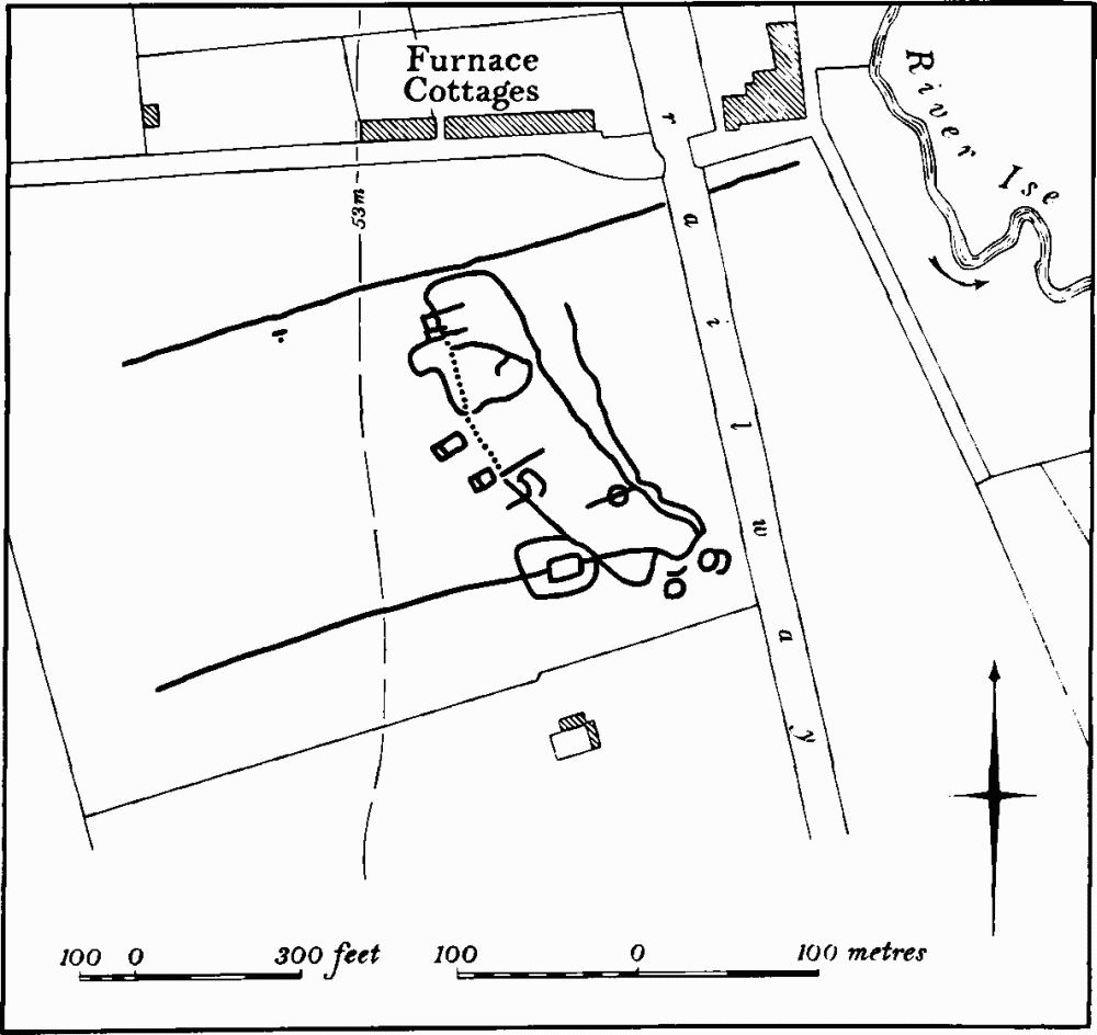
Fig. 78 Little Harrowden (2) Cropmarks
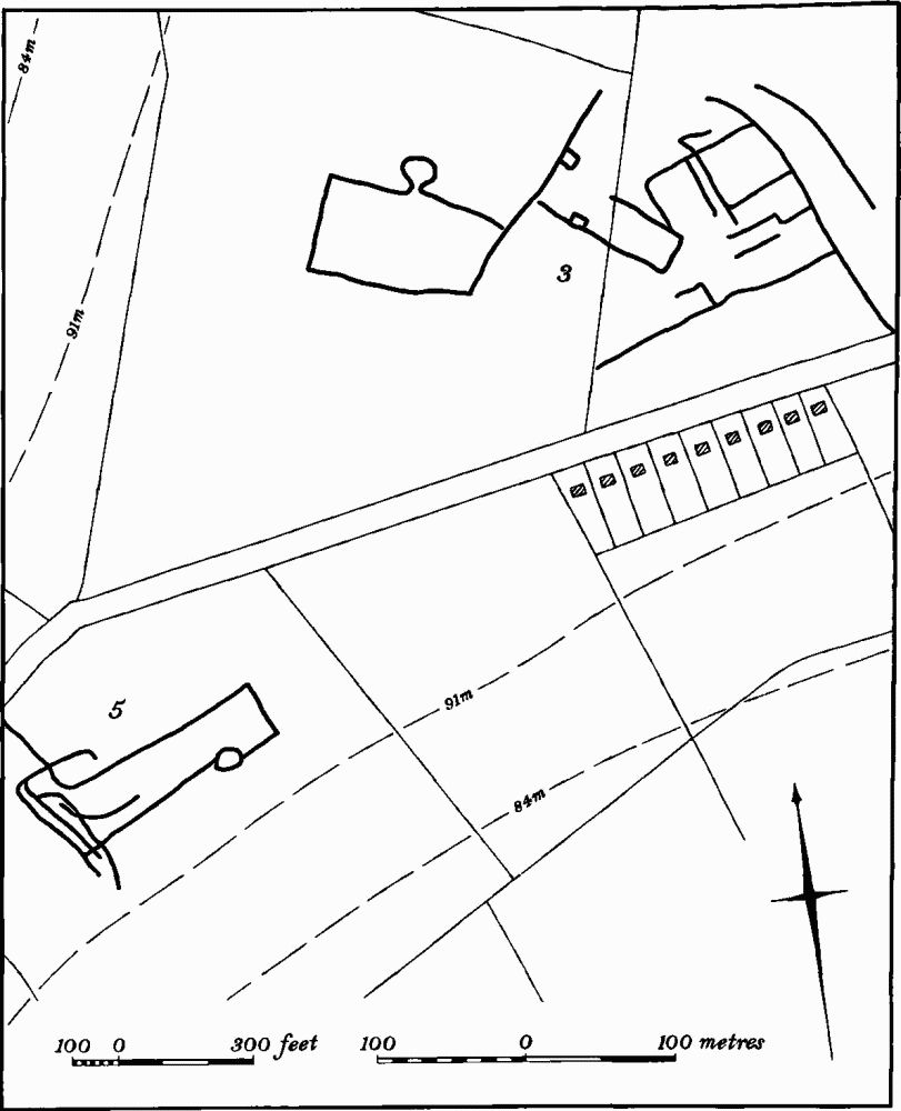
Fig. 79 Little Harrowden (3, 5) Cropmarks
b(7) Mound (SP 87637190), lies N.E. of the village, on Northampton Sand at 96 m. above OD. It is 30 m. in diam. and 0.5 m. high and has been ploughed. There are many fragments of stone and limestone roof slabs, and roof tiles of Lyveden type. In addition a little medieval and post-medieval pottery has been found on it, as well as three flint blades (BNFAS, 4 (1970), 5, 17).
(8) Cultivation Remains. The common fields of the parish were enclosed by an Act of Parliament of 1781. Ridge-and-furrow of these fields can be traced on the ground or on air photographs in the W. of the parish and around the village, though little has survived E. of the village. Most of the ridge-and-furrow is in end-on furlongs, though there are some interlocked furlongs which appear to be determined by the relief, the ridges being orientated at right-angles to the contours (e.g. at SP 855705 and 856710). There are several well-marked headlands up to 300 m. long and 25 m. wide (e.g. at SP 856710 and 853708). The most impressive of these (from SP 858703 to 868713) is some 1500 m. long, with several sharp changes of direction.
In the extreme W. part of the parish is a small area known as Breach Close which was part of the Lordship of Wythmail in 1754 (Map in NRO) and must have been cleared woodland. However there is no trace of ridge and-furrow within this area (RAF VAP CPE/UK/1925, 1358–60, 3351–64, 2351–6, 3238–44, 4233–8; F21 540/RAF/1312, 0246–8, 0204–15; F22 540/RAF/ 1312, 0204–8; 541/611, 3067–70).