An Inventory of the Historical Monuments in the County of Northamptonshire, Volume 1, Archaeological Sites in North-East Northamptonshire. Originally published by Her Majesty's Stationery Office, London, 1975.
This free content was digitised by double rekeying. All rights reserved.
'Tansor', in An Inventory of the Historical Monuments in the County of Northamptonshire, Volume 1, Archaeological Sites in North-East Northamptonshire(London, 1975), British History Online https://prod.british-history.ac.uk/rchme/northants/vol1/pp92-94 [accessed 1 February 2025].
'Tansor', in An Inventory of the Historical Monuments in the County of Northamptonshire, Volume 1, Archaeological Sites in North-East Northamptonshire(London, 1975), British History Online, accessed February 1, 2025, https://prod.british-history.ac.uk/rchme/northants/vol1/pp92-94.
"Tansor". An Inventory of the Historical Monuments in the County of Northamptonshire, Volume 1, Archaeological Sites in North-East Northamptonshire. (London, 1975), British History Online. Web. 1 February 2025. https://prod.british-history.ac.uk/rchme/northants/vol1/pp92-94.
46 TANSOR
(OS 1:10000 a TL 09 SW, b TL 09 SE, c TL 08 NE)
The parish occupies a long narrow strip of land covering some 590 hectares, rising E. from the R. Nene, which forms its W. boundary, at 55 ft. above OD to a maximum height of 225 ft. above OD. The higher S.E. third is on Boulder Clay, and there is a large outcrop of Oxford Clay in the centre of the parish. In the N.W., on the lower ground, are extensive areas of limestone and River Gravel. The latter deposits have on them a number of sites visible from the air, including the major complex of occupation near Tansor Grange (1–3).
Prehistoric and Roman
bc(1–3) Tansor Grange Complex (Fig. 99; Plate 4), S.W. of the village on a generally flat area of Cornbrash at 75 ft. above OD. Air photographs reveal crop-marks covering a very large area, all indicating a complicated sequence of settlement. They lie immediately W. of the line of the Irchester-Water Newton Roman road (570). The remains are located in three main groups. (CUAP, AFZ97–101, AAP57–60; air photographs in NMR)
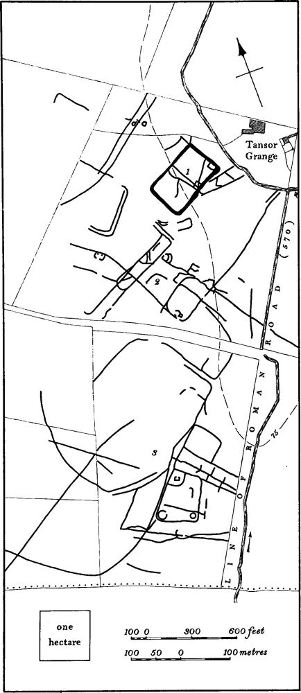
Fig. 99 Tansor (1–3) Tansor Grange Complex
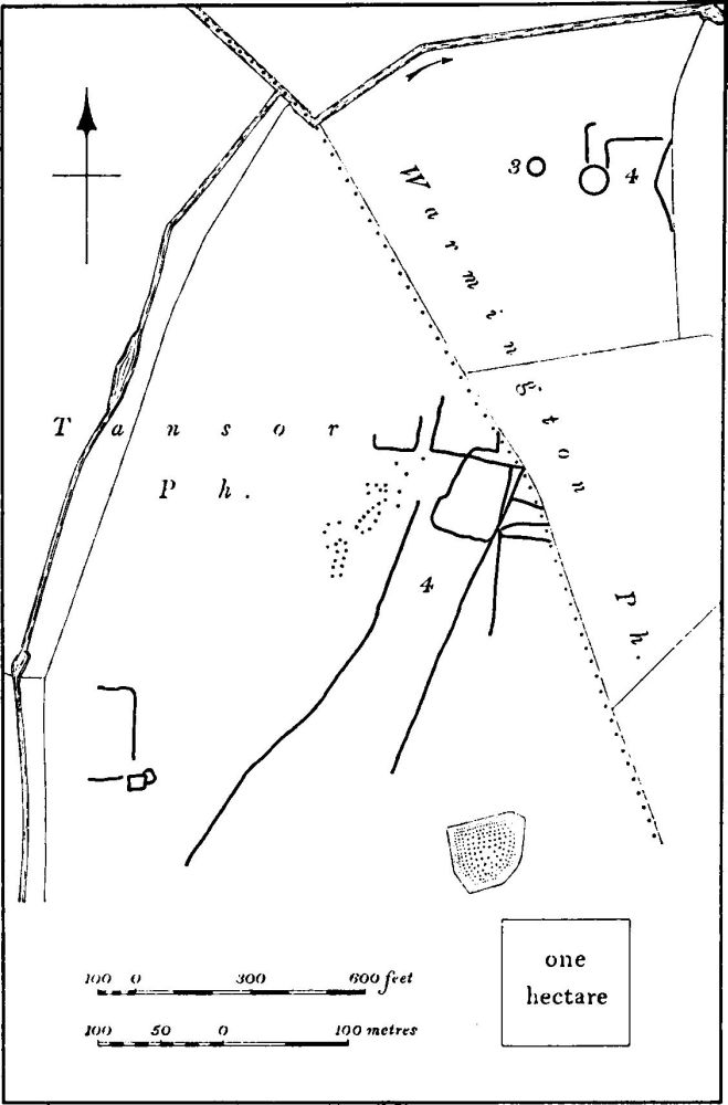
Fig. 100 Tansor (4) and Warmington (3 and 4) Crop-marks
b(1) Enclosure (TL 06929021; Plate 4) consists of a large rectangular enclosure orientated S.W.-N.E., bounded by an unusually wide and irregular ditch. A number of features including a small enclosure in the E. corner is visible in the interior. There is no trace of an entrance.
bc(2) Settlement (TL 06809000; Plate 4), W., S.W. and S. of (1), consists of a highly complex system of ditches and enclosures, including at least two circular hut sites and a small rectangular enclosure with two large pits inside it. The associated linear ditches extend S.E. to join (3).
c(3) Roman Settlement (TL 06708970), S.W. of (2), consists of a complex pattern of ditches and enclosures, including two well-marked circular hut sites and a small rectangular ditched enclosure. Within this area quantities of Roman material have been discovered. Iron slag, building-materials and two 4th-century coins were found in 1961. (BNFAS, 4 (1970), 42; 6 (1971), 17, Tansor (2), pl. 3 (4))
b(4) Settlement (TL 05239212; Fig. 100), N.N.W. of the village, close to the flood-plain of the R. Nene on River Gravel at 60 ft. above OD. Air photographs show a group of linear ditches and enclosures, together with a large number of circular pits (CUAP, ZF35–37).
b(5) Ring Ditch and Trackway (TL 05409149), 600 m. N. of Tansor village on River Gravel at 75 ft. above OD. The ring ditch has a diameter of 25 m. Immediately to the N. are two parallel ditches 5 m. apart, probably a trackway, running E.-W. The ditches can be traced on air photographs from a point close to the R. Nene (TL 05139145), across the parish boundary with Warmington (at TL 05549151), to a point N.W. of the old railway (TL 05869141) where they turn N.E. to join a settlement site on the edge of the R. Nene flood-plain (Warmington (5), Fig. 113). The total traceable length is slightly over 1 km. (CUAP, ABN67).
c(6) Ring Ditch and Enclosure (?) (TL 07838985), in the N.E. of the parish on Oxford Clay at 100 ft. above OD. Diam. of the ring ditch 35 m. To the N. (at TL 07858994), air photographs show indistinctly what may be a sub-rectangular enclosure of just under 0.5 hectares. (BNFAS, 6 (1971), 17, Tansor (1))
For Roman Road 570, see p. 116.
Medieval and Later
bc(7) Deserted Village of Elmington (around TL 056900; Fig. 10) probably lay S. of Tansor village alongside the present A605 road, N. of Tansor Lodge. There were once apparently two separate, but adjacent, settlements called Elmington, one in Tansor and the other in Ashton. For the documented history of both see Ashton (5). Small quantities of medieval pottery have been found in the area, but intensive settlement is not indicated.
(8) Cultivation Remains. The common fields were enclosed in 1778 following an Act of Parliament of 1777 (VCH Northants., II (1906), 595). Ridge-and-furrow of these fields survives on the ground or is visible on air photographs in parts of the parish, but only in the S.E. half is sufficient traceable to indicate the arrangement of furlongs which are end-on and interlocked, mainly of reversed-S shape. The extreme S.E. of the parish, on Tansor Wolds, appears to be devoid of ridge and-furrow and was perhaps never under cultivation during the medieval period. (RAF VAP CPE/UK 1925, 1113–5; 2109, 3091–2, 4229–30, 4378–84, 4401–10)