An Inventory of the Historical Monuments in Herefordshire, Volume 1, South west. Originally published by His Majesty's Stationery Office, London, 1931.
This free content was digitised by double rekeying. All rights reserved.
'Dorstone', in An Inventory of the Historical Monuments in Herefordshire, Volume 1, South west(London, 1931), British History Online https://prod.british-history.ac.uk/rchme/heref/vol1/pp55-58 [accessed 1 February 2025].
'Dorstone', in An Inventory of the Historical Monuments in Herefordshire, Volume 1, South west(London, 1931), British History Online, accessed February 1, 2025, https://prod.british-history.ac.uk/rchme/heref/vol1/pp55-58.
"Dorstone". An Inventory of the Historical Monuments in Herefordshire, Volume 1, South west. (London, 1931), British History Online. Web. 1 February 2025. https://prod.british-history.ac.uk/rchme/heref/vol1/pp55-58.
In this section
22 DORSTONE (B.b.)
(O.S. 6 in. (a)XXXI, N.E., (b)XXXI, S.W., (c)XXXI, S.E., (d)XXXII, N.W., (e)XXXII, S.W.)
Dorstone is a large parish 12 m. W. of Hereford. Arthur's Stone and the earthworks of Dorstone Castle are the principal monuments.
Pre-historic
a(1). Arthur's Stone (Plate 89) on the top of a ridge, nearly 1 m. N.N.E. of the church, is the chamber and entrance-passage of a barrow from which the covering earth has been washed away or removed. The actual chamber retains nine of the enclosing stones, but only five of these now support the cap-stone. This cap-stone, of irregular form, 19 ft. long by 11 ft. wide and 1¾ ft. at its greatest thickness, has broken in half and the northern part now rests on the ground. N. of the chamber is a corridor, 2½ to 3 ft. wide, which makes a right-angled bend 8 ft. N. of the cap-stone and continues some 11 ft. to the W.; the enclosing stones of this corridor are mostly in position, but none of the cover-stones remains. About 11 ft. S. of the chamber are two more stones which probably mark the outer boundary, in this direction, of the enclosing mound. Traces of the mound remain around the chamber but are insufficient to determine its precise form.
Condition—Good. In charge of H.M. Office of Works.
Ecclesiastical
c(2). Parish Church of St. Faith, was re-built in 1826, and again in 1889, but incorporates some features from the earlier building.
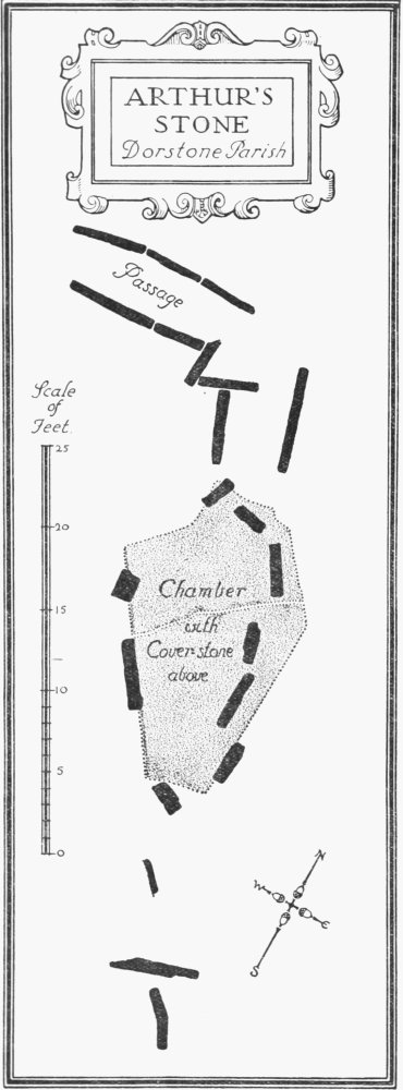
Arthur's Stone, Dorstone Parish
The late 13th-century E. window is of four trefoiled lights, with soffit-cusping and plain tracery in a two-centred head. The late 14th-century window in the E. half of the S. wall of the chancel is of two trefoiled lights with a quatrefoil in a two-centred head; the late 13th-century western window, in the same wall, is of two trefoiled lights, with soffit-cusping in a two-centred head. The N. chapel has a window in the N. wall similar to the S.E. window in the chancel; in the W. wall is a 13th-century lancet-window. The 13th-century tower-arch of white tufa is two-centred and of two chamfered orders, the inner dying on to the responds. The 14th-century S. doorway has stopped jambs of two moulded orders and a two-centred head. All the above have been more or less restored.
Fittings—Bells: four; 1st and 3rd by John Finch, 1650 and 1654; 2nd, inscribed in Lombardic capitals, "Eternis annis resonet campana Johannis," probably from Gloucester Foundry, 15th-century; 4th, dated 1639. Coffin-lids: In tower—lower part of slab with part of inscription in Lombardic capitals and stem of staff, late 13th-century. In rectory garden—defaced. Communion Table: In rectory—with heavy turned legs and enriched top rails, early 17th-century, top modern. Font: octagonal stem and moulded base, early 14th-century, bowl modern. Inscription: In chancel—two fragments of a stone sill (Plate 36), with a dedication-inscription in Lombardic capitals—"Johs. Br[ito] . . . [capel]lam in honore bea[te] Marie . . . tre MCCLV(I?)." Monuments and Floor-slabs. Monuments: In tower—on N. wall, (1) to Roger Smith, 1711, and Elizabeth, his wife, 1712, oval tablet with scrolled and carved border. In churchyard—S. side, (2) to William Madey, 1703–4, low table-tomb; W. side, (3) to Nicholas Wood, 1714–15, and Joice, his wife, 1691, flat slab; (4) to Anne, wife of Simon Gannell, and to the wife of Thomas Bullock, 1707, low table-tomb. Floor-slabs: In nave—(1) to John Partridge, 1678; (2) to Margaret, wife of John Partridge, 1680; (3) to . . ., 1684–5. In tower—(4) to E.M., 1694. Piscinæ: In chancel—recess (Plate 60) with moulded jambs and two-centred outer order of arch, cinque-foiled and sub-cusped inner order, springing from corbel-shafts with moulded capitals, round and octofoiled drains, late 13th-century, at back of recess moulded bracket with dog-tooth ornament, mid 13th-century. In N. chapel—recess with trefoiled ogee head and round drain, 14th-century, partly restored. Plate: includes cup (Plate 57) and cover-paten of 1571, with bands of incised ornament, modern cross on top of paten; in recess in chancel—coffin-chalice (Plate 56) of pewter with knop and broad foot, late 13th-century. Recess: In chancel—in S. wall, low recess with moulded jambs, segmental-pointed arch and label, late 13th-century, partly restored, probably tomb-recess. Scratchings: On S. doorway—masons' marks. Stoup: In nave—W. of S. doorway, semi hexagonal bracket with oval bowl, mediæval. Sundial: On gate-piers of churchyard—two stone balls, one with incised dial-figures, probably late 17th-century.
Condition—Rebuilt.
Secular
c(3). Dorstone Castle (Plan, p. xxxv), motte and bailey earthwork, 300 yards S.W. of the church, stands in a valley just E. of the village. The motte is of oval form, 67 yards by 61 yards across at the base; it has a flat top rising about 28 ft. above the bottom of the surrounding dry ditch, which has an outer bank towards the stream. The kidney-shaped bailey adjoins the motteditch on the N.E. and has remains of a ditch on its S. side. The former scarp on the E. has been largely destroyed by buildings and gardens. The area covered by the motte and bailey is about 2½ acres.
Condition—Fairly good.
b(4). Tump, 220 yards N.W. of Nant-y-Bar and 2¼ m. W.S.W. of the church, is a circular mound 37 yards in diameter rising 8½ to 12½ ft. above the bottom of the surrounding ditch. There are traces of a rampart round the top and of a small causeway crossing the ditch on the N.E.
Condition—Fairly good.
b(5). Tump (Plan, p. xxxv), at Mynydd-brith, 2 m. W. of the church, consists of an oval mound, 34 yards by 32 yards, with a surrounding ditch and a scarped enclosure to the S.W. The mound rises some 18 ft. above the lowest level of the ditch, but the slopes on the N.W. and S.W. have been cut into to form a footpath. The ditch has been destroyed on the E. side, and on the N. its place is taken by a berm and a steep natural slope. The enclosure on the S.W. is flat and has a steep scarp on the S. and W. and a natural slope on the N.
Condition—Poor.
c(6). Village Cross (Plate 33), on the green, 160 yards S.W. of the church, has an octagonal stone shaft set in a base with chamfered angles, and now level with the ground. On the top of the shaft is a metal sundial dated 1812.
Condition—Good.
Monuments (7–17)
The following monuments, unless otherwise described, are of the 17th century and of two storeys; the walls are of rubble and the roofs are covered with stone slates or modern material. Some of the buildings have exposed ceiling-beams and old chimney-stacks.
Condition—Good or fairly good.
c(7). Cottage, two tenements, 120 yards S.S.W. of the church, is partly of timber-framing with plaster filling.
c(8). Millbrook, Chapel Row, two tenements, 40 yards E. of (7), is of late 17th or early 18th-century date, and of T-shaped plan with the cross-wing at the E. end.
c(9). Schoolhouse, on S. side of green, 180 yards S.W. of the church, is said to be dated 1603, but this date is now covered by ivy.
c(10). Dorstone Mill, 750 yards S.W. of the church, is of L-shaped plan with the wings extending towards the W. and S. It has a number of loop-lights.
c(11). Little Lanafon Farm, house, ¾ m. E. of the church, is of late 17th or early 18th-century date, and has a chimney-stack with four grouped shafts, set diagonally.
c(12). Cross Lodge Farm, house, 1¼ m. E. of the church, has later additions on the E. and N.
d(13). Bodcott Farm (Plate 17), house, about 1¾ m. N.E. of the church, has some timber-framing. The E. wing was built early in the 16th century, and the main block extending to the W. is of rather later date. The S. front has a timber-framed gable at the W. end, and the upper storey of the earlier wing at the E. end has exposed timber-framing. The porch has a timber-framed upper storey resting on two stone piers; the outer entrance has a moulded lintel, and the W. side has an original window with wood and iron bars set diagonally. At the end of the original wing is a bay-window, with canted sides, chamfered frame, mullions and transom. The N. and E. sides of the house have timber-framed upper storeys. The W. chimney-stack has three 17th-century shafts, set diagonally. Inside the building, the S. room of the original block has moulded ceiling-beams and chamfered joists; the adjoining N. room has an old cider-mill. Projecting from the E. side is a stone staircase. Other rooms have exposed ceiling-beams.
a(14). Pen-y-moor, house, about 1 m. N.N.W. of the church, has later additions on the N. and W. sides. Inside the building is an original panelled screen with a seat against it.
a(15). Whitehouse Farm, house, nearly 1½ m. N.W. of the church, has a cross-wing at the E. end. The chimney-stack, at the W. end, has two shafts set diagonally. Inside the building are two original doorways, and, on the first floor, some original panelling with moulded framing.
a(16). Newhouse Farm, house, 80 yards S. of (15), is partly timber-framed.
c(17). Brynspard Farm, house, about 1¾ m. W. of the church, was built late in the 16th or early in the 17th century. The N. side has two windows with stone labels; one of these windows is of five lights with original mullions of wood. The doorway on the S. side has a semi-circular stone porch. The W. chimney-stack has two shafts, one set diagonally. Inside the building are some original panelled partitions.
Unclassified
b(18). Earthwork, 270 yards N.E. of Nant-y-Bar and 2 m. W.S.W. of the church, consists of a bank 5 ft. high and about 60 yards long, revetted on most of the N. side with dry-stone walling. It crosses a slight hollow.
Condition—Good.