An Inventory of the Historical Monuments in Westmorland. Originally published by His Majesty's Stationery Office, London, 1936.
This free content was digitised by double rekeying. All rights reserved.
'Waitby', in An Inventory of the Historical Monuments in Westmorland( London, 1936), British History Online https://prod.british-history.ac.uk/rchme/westm/pp232-237 [accessed 27 November 2024].
'Waitby', in An Inventory of the Historical Monuments in Westmorland( London, 1936), British History Online, accessed November 27, 2024, https://prod.british-history.ac.uk/rchme/westm/pp232-237.
"Waitby". An Inventory of the Historical Monuments in Westmorland. (London, 1936), , British History Online. Web. 27 November 2024. https://prod.british-history.ac.uk/rchme/westm/pp232-237.
In this section
105 WAITBY (G.d.)
(O.S. 6 in. (a)XXIII, S.W., (b)XXX, N.W.)
Waitby is a parish adjoining that of Kirkby Stephen on the W. The principal monuments are Smardale Hall and the village settlements and lynchets.
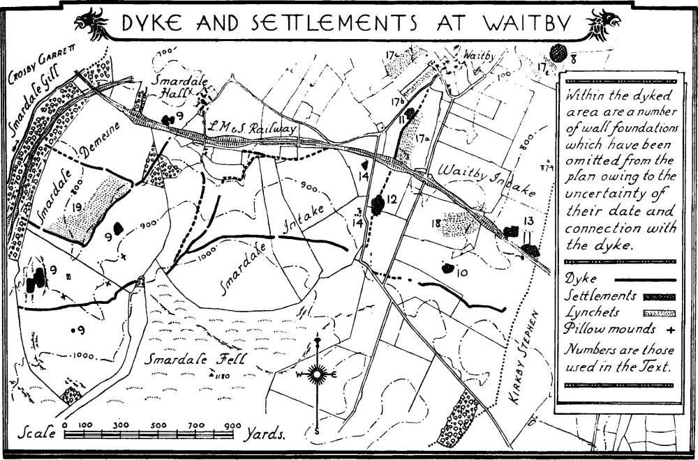
Dyke and Settlements at Waitby
Secular
a(1). Smardale Hall (Plate 18), on the W. side of the parish, is of two storeys with attics; the walls are of rubble and the roofs are slate-covered. The house belonged to the families of Smardale and Warcop in the Middle Ages and passed from the latter to the family of Dalston late in the 16th century. The house seems to have been re-built about this date on an unusual long rectangular plan (86 ft. by 27 ft.) with round towers at the angles. A later wing has been added to the E. of the S. end and the building was restored late in the last century. The angle-towers have a slight batter; they have single-light windows and conical roofs. The N. end retains its two original four-light transomed windows with moulded labels. The two corresponding windows in the S. end have been altered. The windows in the side walls are similar to those in the N. end but the majority of them have been wholly or partly renewed; in the E. wall is an original doorway with a triangular arch in a square head; above it is set a carved boss with foliage, perhaps of the 14th century. Inside the building, the S.E. tower contains a stone staircase and there was formerly a second staircase in the N.W. tower. The kitchen has a wide fireplace with a segmental arch; it is partly filled in.
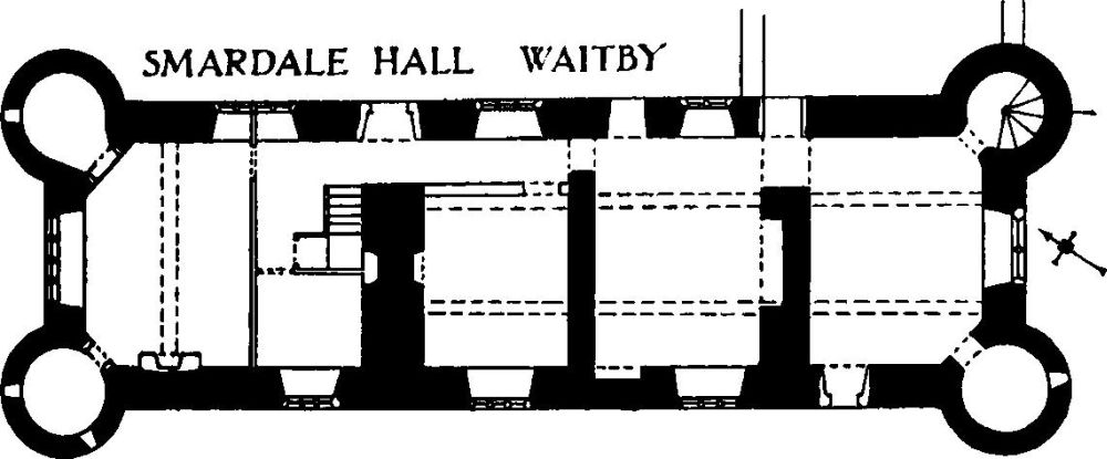
Smardale Hall, Waitby
Condition—Good.
Monuments (2–7)
The following monuments, unless otherwise described, are of the 17th century and of two storeys. The walls are of rubble and the roofs are slate-covered. Some of the buildings have exposed ceiling-beams.
Condition—Good or fairly good, unless noted.
a(2). House, at the W. end of Waitby hamlet and 1,300 yards E. of (1), retains some original windows with a continuous moulded label over the lower range. The doorway has a lintel with the initials and date W. and M.B. 1692.
Condition—Derelict.
a(3) Cottage, 140 yards S.S.E. of (2), was built late in the 17th or early in the 18th century.
a(4). House, 160 yards N.E. of (3), has a re-set stone with the initials and date I. and A.R. 1690. Some of the original windows remain and there was formerly a continuous moulded label over the lower windows on the S.W. front. Inside the building is an original panelled partition enclosing bed-cupboards (Plate 59); these have double doors, the upper panels fitted with balusters.
a(5). Outbuilding, formerly house, 40 yards W.S.W. of (4), has some original windows, with a continuous moulded label over the lower range on the N.W. In the S.W. end is a re-set panel with the initials and date I.E.H. 1690.
a(6). House, 50 yards N.E. of (4), has a higher modern addition on the S. It retains some altered original windows.
a(7) Wharton Farm, house 140 yards N.E. of (2), was built early in the 18th century and retains a lintel with the initials and date W. and I.W. 1714.
Unclassified
a(8) Waitby Castle, earthwork on the E. border of the parish and E. of Waitby hamlet, occupies a natural knoll (756 ft. above O.D.). It forms an oval enclosure surrounded by remains of a ditch and an outer rampart. On the E. side of the enclosure are traces of foundations and slight traces of two parallel dykes extend to the N.E. The site may perhaps be compared with Croglam Castle (Kirkby Stephen).
Condition—Bad.
a and b(9). Village Settlements, dykes and mounds in Smardale Demesne S.W. of (1). The larger settlement, of about 1¼ acres, occupies the top of a ridge (910 ft. above O.D.). It is in two halves, one on each side of the ridge-top leaving a space about 18 yards wide between them, across which are walls connecting the two halves and forming a rectangular enclosure. The main outlines of the village are rather rectangular and resemble the neighbouring settlement at Intake in Crosby Garrett. Towards the S.E. side of the village are traces of what may be a large circular hut, 36 ft. diameter. There are also within the settlement traces of one or two other possible circular or oval shaped huts.
The smaller northern settlement (about ½ acre) lies about 500 yards to the N.E. and is of very unusual form, though its state of decay may be in part responsible for its appearance. Actually it is more suggestive of either a single dwelling or of a cattle enclosure. It consists of a partly oval enclosure with one small subsidiary division while in the larger portion are traces of a structure of roughly circular form about 30 ft. in diameter. The entrance would appear to have been on the N.E. The site is on a slight slope downwards to the N.W.
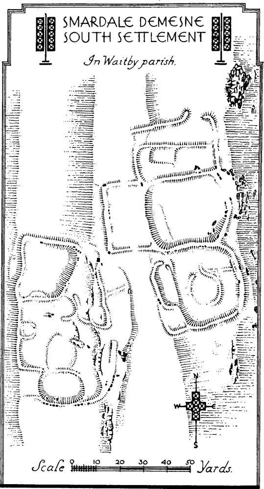
Smardale Demense, South Settlement, in Waitby parish.
Crossing this work and joining up two portions of the dyke (see below) are the foundations of a wall which presumably is of later date than the enclosure it crosses, but on the other hand, there is nothing to indicate that it is of the same age as the dyke.
Traces of what was perhaps a third settlement exist about 200 yards S.W. of Smardale Hall.
The Dyke encloses an area of uncertain size since it cannot be traced for the whole of its length but it certainly enclosed not less than 450 acres mainly S. of the L. M. and S. Railway and bordering the Scardale beck gorge on its eastern bank. There are a number of cross dykes dividing it up into several enclosures. The dyke consists of a bank about 12 to 15 ft. across at its base and for much of its length about 4½ ft. high. A number of large stones of orthostatic type still remain in the W. portion, but they all seem to be on one side only of the dyke as though it had been revetted on one side only and that the side on which was the spoil-ditch.
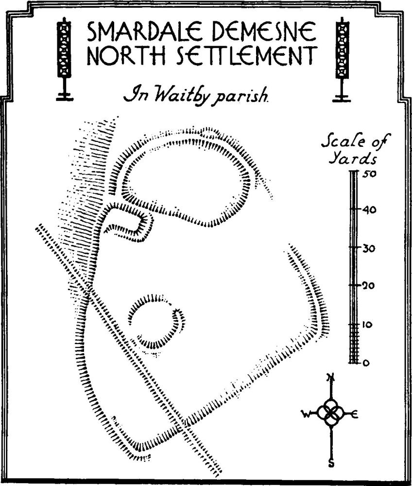
Smardale Demesne, North Settlement, in Waitby parish.
Three mounds, in the form of pillow-mounds, lie to the E. and S.E. of the larger settlement. They vary from 30 to 45 ft. long by 12 to 18 ft. wide.
Outside the dyke, about 300 yards S.E. of the southern settlement, are traces of a square enclosure, 21 ft. by 18 ft. and perhaps of no great age.
Condition—Poor.
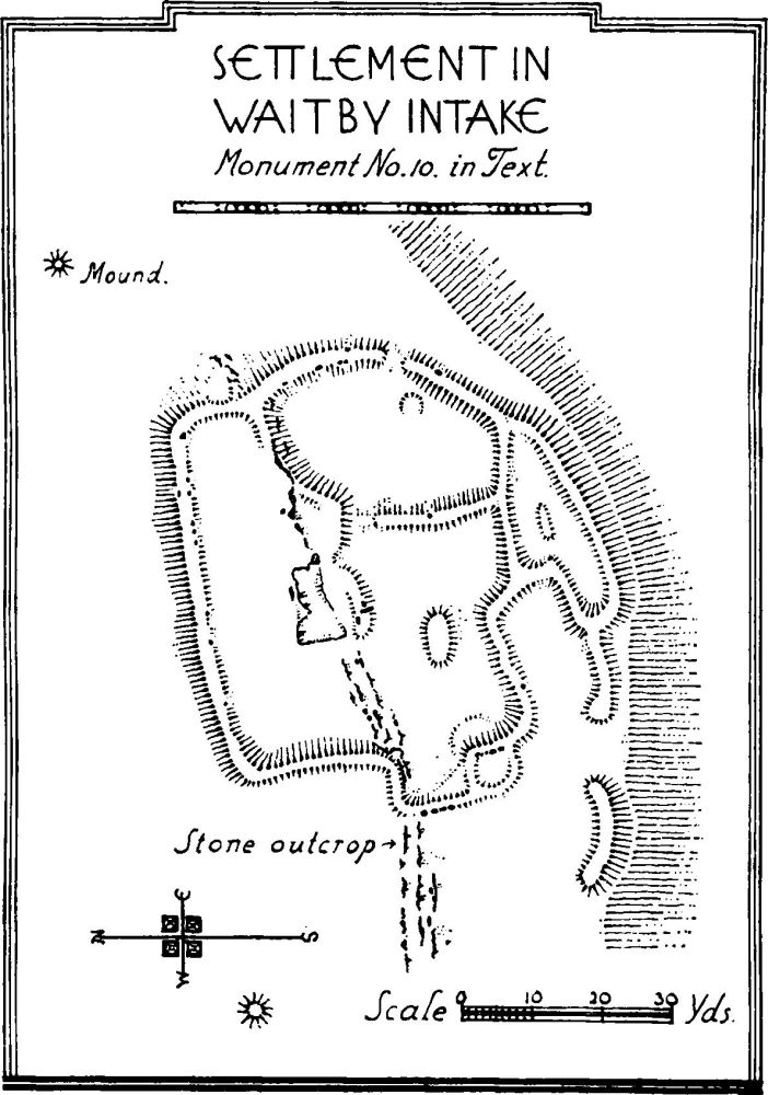
b(10). Village Settlement (820 ft. above O.D.) 1 m. S.E. of (1) and near the E. border of the parish, is of irregular oval form and nearly 1 acre in area. It has the usual irregular divisions and traces of one or more huts. A few orthostats remain. There are two slight mounds to the N.E. and W. of the settlement.
Condition—Bad.
a(11). Earthworks, possibly settlement, 350 yards S.W. of (2), consist of a slight circular sinking, possibly a hut, and traces of other disturbance of the ground in the immediate neighbourhood.
a(12). Village Settlement, on Tom Bank (850 ft. above O.D.), 1,100 yards E.S.E. of (1), is crossed by a modern field-wall, on the S. side of which the site has been quarried and largely obliterated. On the N. of the wall are remains of the usual irregular enclosures, with traces of a wall or dyke extending N. and S. from it.
Condition—Bad.
Settlement in Waitby Intake, Monument No.13 in Text.
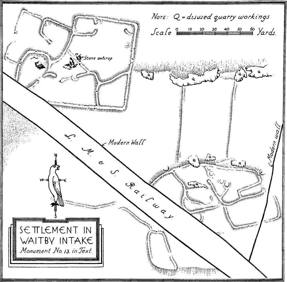
a(13). Village Settlement, in Waitby Intake (815 ft. above O.D.) adjoining the railway, 1 m. E.S.E. of (1), consists of two separate villages probably connected by the walls of a field-system. The S. part of the S.E. village has been largely destroyed by the railway. It was about 1¼ acres in extent and consisted of the usual irregular enclosures. There is a possible entrance on the E. side. Towards the N. are traces of at least three circular huts. A few orthostats remain indicating walls 5½–6 ft. thick. The N.W. village is unusually rectangular in form and is probably of later date. The walls are of about the same thickness as in the first village and the huts seem to have all been built against the enclosure-walls. The entrance on the W. side has traces of curving in of the wall on the S. side. This entrance opens into an enclosure, perhaps a later addition. The area is just over 1 acre.
Settlement in Waitby Intake, Monument No.13 in Text.
Condition. Of S.E. village, poor; of N.W. village, fairly good.
a(14). Foundations, on the W. side of the lane nearly ¾ m. S.E. of (1), represent former rectangular structures, possibly of no great age. About 250 yards to the N. is a triangular enclosure.
b(15). Mound, on Rassett Hill 1¾ m. S. of (1), is about 55–57 ft. in diameter and 5 ft. high. The centre has been disturbed. This is probably the mound examined by Greenwell (Brit. Barrows CLXV, p. 382) who found the burnt bones of an adult.
b(16). Mounds, called Giants' Graves, in the form of pillow-mounds, in the S.W. corner of the parish. They are ten in number and vary from 20–75 ft. in length and from 15–18 ft. in width. The height is from 3–4 ft. (See Ravenstonedale 33.)
a(17). Lynchets, in five groups surrounding Waitby hamlet. Group (a), S.S.W. of the hamlet, on a S.E. slope, are four in number. They have a maximum length of 180 yards with a drop of from 4–7 ft. Group (b), S.W. of the hamlet on a N.W. slope, is fragmentary. Group (c), W. of the hamlet, on a S.E. slope, are six in number and about 200 yards in length. There are indications of subdivisions in the wider lynchets. Group (d), N.W. of the hamlet on an E.N.E. slope, are about 280 yards long. Group (e), E. of the hamlet on a S.W. slope, is fragmentary.
a(18). Lynchets, 200 yards N. of (10) on a S. slope, are fragmentary.
a(19). Lynchets, within the dyked enclosure of (9) on a N.E. slope, are about 85 yards long.
a(20). Lynchets, 300 yards N. of (1), are fragmentary.
a(21). Lynchets, 200 yards N.E. of Bowber Hill on a N.E. slope.
