An Inventory of the Historical Monuments in Westmorland. Originally published by His Majesty's Stationery Office, London, 1936.
This free content was digitised by double rekeying. All rights reserved.
'Staveley, Nether', in An Inventory of the Historical Monuments in Westmorland( London, 1936), British History Online https://prod.british-history.ac.uk/rchme/westm/pp218-219 [accessed 27 November 2024].
'Staveley, Nether', in An Inventory of the Historical Monuments in Westmorland( London, 1936), British History Online, accessed November 27, 2024, https://prod.british-history.ac.uk/rchme/westm/pp218-219.
"Staveley, Nether". An Inventory of the Historical Monuments in Westmorland. (London, 1936), , British History Online. Web. 27 November 2024. https://prod.british-history.ac.uk/rchme/westm/pp218-219.
In this section
93 STAVELEY, NETHER (C.f.)
(O.S. 6 in. (a)XXXIII, N.W., (b)XXXIII, S.W., (c)XXXIII, S.E.)
Nether Staveley is a parish 4 m. N.W. of Kendal. Hollin Hall is the principal monument.
Secular
a(1). Gowan Bridge, on the N.E. edge of the parish, carries the Kendal-Windermere road over the Gowan. It was built probably in the 17th century but may have been widened perhaps on the E. side. It is a rubble structure of two spans, with round arches and cutwaters to the central pier. Both the pier and abutments are deflected for the current of the stream.

Nether Staveley, Hollin How
Condition—Good.
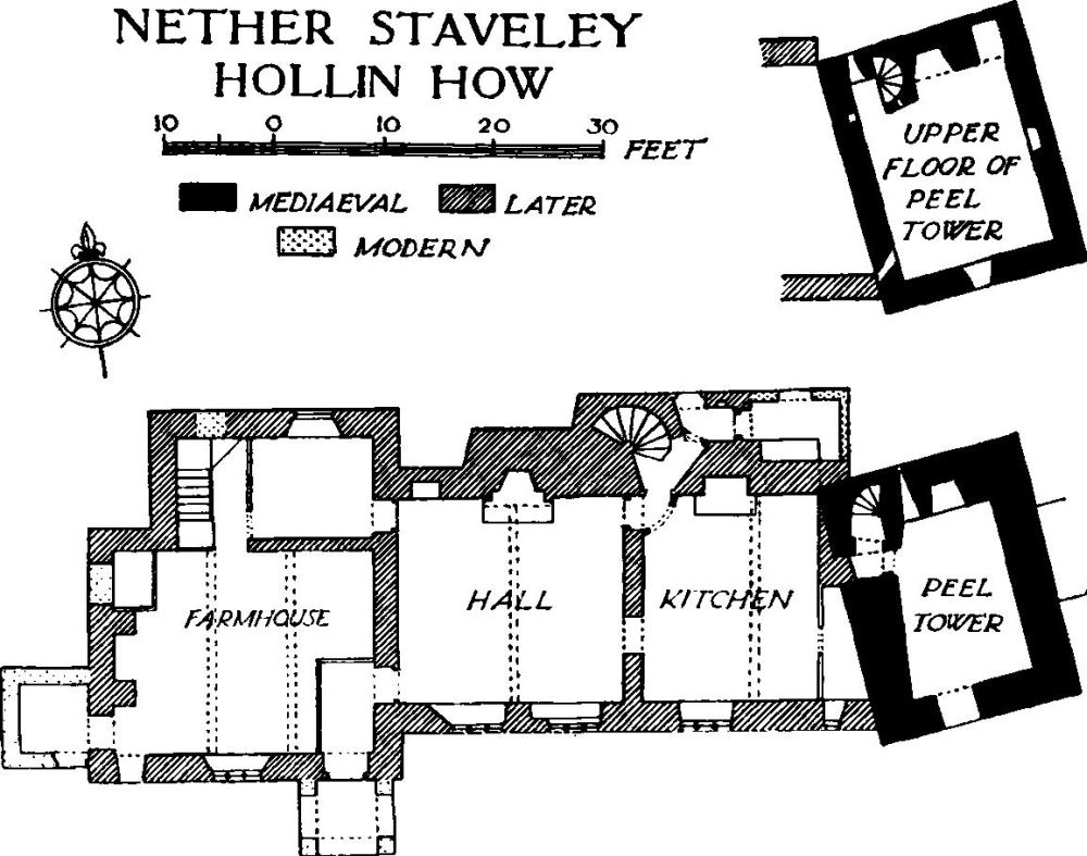
b(2). Hollin How or Hall (Plate 16), in the S. angle of the parish, is of two storeys partly with attics and cellars. The walls are of rubble and the roofs are slate-covered. The pele-tower at the E. end of the house is probably of 14th or 15th-century date but has no distinctive features; the upper part is gabled, probably a later alteration. The adjoining part of the house was added late in the 16th or early in the 17th century and the W. wing is perhaps a late 17th or early 18th-century addition. The tower has crow-stepped gables and a heavy chimney-stack with a round shaft on the N. The house is covered with rough-cast but a string course is carried along the S. front over the lower windows. Two chimney-stacks have each two conjoined round shafts and a stack on the N. side has a single round shaft. Inside the building, the tower has a barrel-vault to the lower storey and a fireplace in the N. wall with a heavy lintel. The spiral staircase is original and adjoining it is a loop-light. On the upper floor is a second loop and a fireplace with a flat lintel; in the N. wall is a deep recess perhaps for a garde-robe. The house has some exposed ceiling-beams and in the hall is a cupboard of the usual local type, with the initials and date C. and M.D. 1667; it is not, however, a fixture. On the first floor is some early 17th-century panelling refixed.
Condition—Good.
Monuments (3–11)
The following monuments, unless otherwise described are of the 17th century and of two storeys; the walls are of local rubble and the roofs are slate covered. Some of the buildings have exposed ceiling-beams.
Condition—Good or fairly good.
b(3). Knott, formerly house, now cattle-shed, 800 yards E. of (2).
b(4). Ashes, house 1,120 yards N.N.E. of (2), has been largely re-built and the E. part heightened in the 18th century. The early 18th-century staircase has turned balusters and square newels. A cupboard door has the initials and date R.S. 1723.
b(5). Little Ashes, house 600 yards E. of (4), has a drip-stone course over the lower windows. Inside the building a cupboard has the initials and date R. and M.F. 1721.
c(6). Crag, house in the E. angle of the parish over 1 m. E.S.E. of the station, is of L-shaped plan with the wings extending towards the S. and W. In the N. wall is an original window with diamond-shaped mullions. Inside the building is an original panelled door.
b(7). Sandyhill, house on the N.E. side of the road 700 yards S.E. of the station, has been much altered and heightened by one storey. Inside the building is some original panelling, including a carved frieze with the initials and date R. and M.M. 1688.
b(8). Stockbridge Farm, house 150 yards W. of (7), has probably been heightened. Inside the building is a cupboard said to be dated 1670.
b(9). Borwick Fold, house nearly 2 m. S.W. of the station, is of L-shaped plan with the wings extending towards the W. and N. Inside the building is a fixed cupboard of the local type with a carved frieze, pendants and the initials and date R. and M.G. 1702.
b(10). Yews, house 650 yards N.W. of (9), has an added porch on the S. Inside the building is an original boarded partition and some panelled doors.
b(11). High Fairbank, house 580 yards N.E. of (10).
