An Inventory of the Historical Monuments in Westmorland. Originally published by His Majesty's Stationery Office, London, 1936.
This free content was digitised by double rekeying. All rights reserved.
'Stainmore', in An Inventory of the Historical Monuments in Westmorland(London, 1936), British History Online https://prod.british-history.ac.uk/rchme/westm/pp215-217 [accessed 7 February 2025].
'Stainmore', in An Inventory of the Historical Monuments in Westmorland(London, 1936), British History Online, accessed February 7, 2025, https://prod.british-history.ac.uk/rchme/westm/pp215-217.
"Stainmore". An Inventory of the Historical Monuments in Westmorland. (London, 1936), British History Online. Web. 7 February 2025. https://prod.british-history.ac.uk/rchme/westm/pp215-217.
In this section
91 STAINMORE (H.d.)
(O.S. 6 in. (a)XVI, S.E., (b)XVII, S.W., (c)XXIII, N.E., (d)XXIV, N.W., (e)XXIV, N.E.)
Stainmore is a parish on the E. border of the county 5 m. N.E. of Kirkby Stephen. The Roman fort at Maiden Castle is the principal monument.
Roman
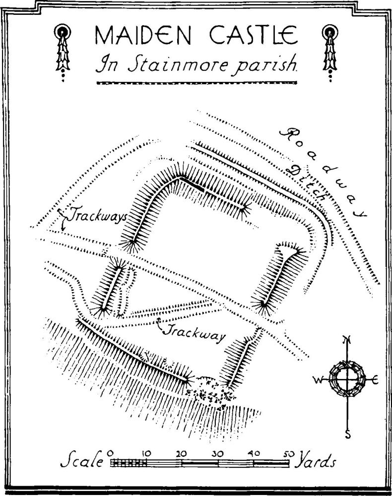
e(1). Maiden Castle (Plate 151), Roman fort and settlement, on a scarp on the N. side of the BroughBowes road and 50 yards S. of the old coach-road, 2 m. E. of the parish church. The fort is about 50 yards (N. to S.) by 40 yards, giving an internal area of nearly ½ acre. The rampart has been much robbed and only near the N.W. angle can any facing stones be seen. In 1862, however, Prebendary Scarth found some 20 ft. of rampart exposed and noted that the wall was 6 ft. thick with a core of limed rubble. The rampart is completely destroyed at the N.E. angle, while the S.W. angle has slipped down the hillside. The ditch system is uncertain, though it seems clear that there was at least one ditch on the N. side, which is the most vulnerable. It is impossible, without digging, to differentiate certainly between ditches and later tracks. There appears to have been a central gateway in the E. and W. sides though there is nothing to show their form. Across the station and through these gates runs a pack horse track 6 to 8 ft. wide with a secondary track and worn to a depth of 3 to 4 ft.; it has been suggested by Prof. R. G. Collingwood that this 'hollow way' occupies the site of the Roman road. The latter is clearly visible S. of the coach road up to a point about 100 yards E. of the station; farther W. the surface is seamed with old tracks, but it seems probable the road passed through the fort and was subsequently diverted round the N. side of it.

Maiden Castle, in Stainmore parish.
There are now no indications of the internal arrangements. In 1914, however, the Rev. T. Westgarth, in excavating the interior, found traces of stone buildings. Finds of Roman objects have occurred in 1880 and 1914. The latter included a small group of potsherds, the earliest of the late 2nd but the majority of the 4th century and a 4th-century coin. (C. and W. Trans. N.S. XXVII, p. 170.)
About 100 yards to the E. are a number of ruined stone enclosures, most of them about 30 ft. by 20 ft.; some of them are roughly rectangular. It has been suggested that they may be part of a village-settlement.
Condition—Poor.
Ecclesiatical
d(2). Parish Church of St. Stephen, S. Stainmore, formerly a chapel of Brough, stands towards the W. side of the parish. The former chapel, consecrated in 1608, was entirely re-built in 1842. It contains the following old—
Fitting—Chair: In chancel—with turned legs, shaped arms, enriched panelled back with cresting, late 17th-century. In the modern chapel of St. Mary, N. Stainmore, is a chair with the initials and date A.M. 1688. Miscellanea: Incorporated in the school-house at S. Stainmore—stone door-lintel with the date 1673.
Secular
Monuments (3–17)
The following monuments, unless otherwise described, are of the 17th century and of two storeys. The walls are of rubble and the roofs are slate-covered. Some of the buildings have exposed ceiling-beams.
Condition—Good or fairly good, unless noted.
d(3). Swinstone House, 660 yards S.W. of St. Stephen's church, retains two original stone windows at the back and two original doorways. The front doorway has embattled enrichment on the lintel (Plate 30) and the initials and date W.W. 1683; the back doorway has curvilinear enrichment on the lintel. Inside the building is an early 18th-century fireplace with a corbelled head.
d(4). Cavalade, ruined cottage 750 yards E.S.E. of St. Stephen's church, retains remains of original windows.
Condition—Ruined.
d(5). Bleathgill, house nearly 1 m. E. of St. Stephen's church, was re-built in the 18th century, but adjoining it on the W. the earlier building now forms an outhouse. It retains some blocked original windows.
d(6). Rampson, house 620 yards N.N.W. of (5), was re-built in 1766, but incorporates a panel with the initials and date W. and M.S. 1630.
b(7). Light Trees, house 1 m. N.N.E. of St. Stephen's church, retains two blocked original windows.
b(8). Littlethwaite, house 1,050 yards W.S.W. of (7), has been re-built except for a partly ruined portion at the E. end.
b(9). Longcrag House, 1,500 yards N.E. of St. Mary's church, retains two original windows and some moulded ceiling-beams.
b(10). Borrowdale House, 750 yards N.N.E. of St. Mary's church, has a re-set original door-head with a triangular arch in a square head.
b(11). House, on Dummah Hill 700 yards S.W. of (10), has a stone panel with the initials and date I.I. 1696. There is also a spice-cupboard with enriched doors.
d(12). Crag House, 1,250 yards N.W. of St. Stephen's church.

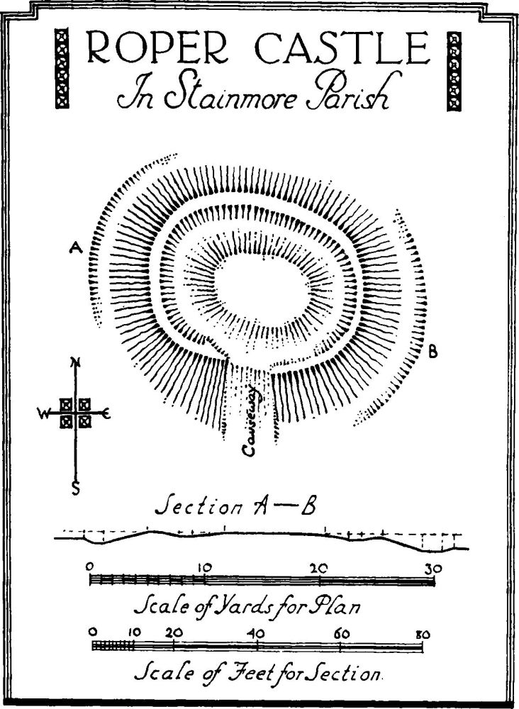
Roper Castle, in Stainmore Parish
c(13). Cottage, nearly 2 m. W. of St. Stephen's church, was built early in the 18th century and has been heightened.
c(14). Park House, 110 yards W. of (13), is modern but incorporates a door-head with the initials and date I.I.E. 1714.
c(15). Duck Pool, house 650 yards W.S.W. of (14), was built probably early in the 18th century.
a(16). Parkhouse Farm, house 350 yards N. of (14), retains some original panelled doors.
d(17). New Hall, about 1¼ m. S. of St. Stephen's church, was built probably early in the 18th century.
Unclassified
e(18). Roper Castle or Round Table, earthwork, 2¾ m. S.E. of the parish church, occupies the E. end of a flat-topped hill. The work is of oval form about 76 ft. by 61 ft. including the surrounding bank which is about 5 to 10 ft. wide, and 3 ft. high. Outside the bank are traces of a slight ditch and within the area is a raised platform, nowhere more than 1 ft. high, and about 22 ft. by 17 ft. across. There are traces of a causeway on the S. side.
Condition—Fairly good.
a(19). Dyke, called Maiden Way, 1 m. S.W. of N. Stainmore, consists of a bank 1 to 2½ yards wide with a ditch on the N. side. It can be clearly traced for a distance of about ½ m., running in a direction W.S.W and E.N.E.
Condition—Fairly good.
